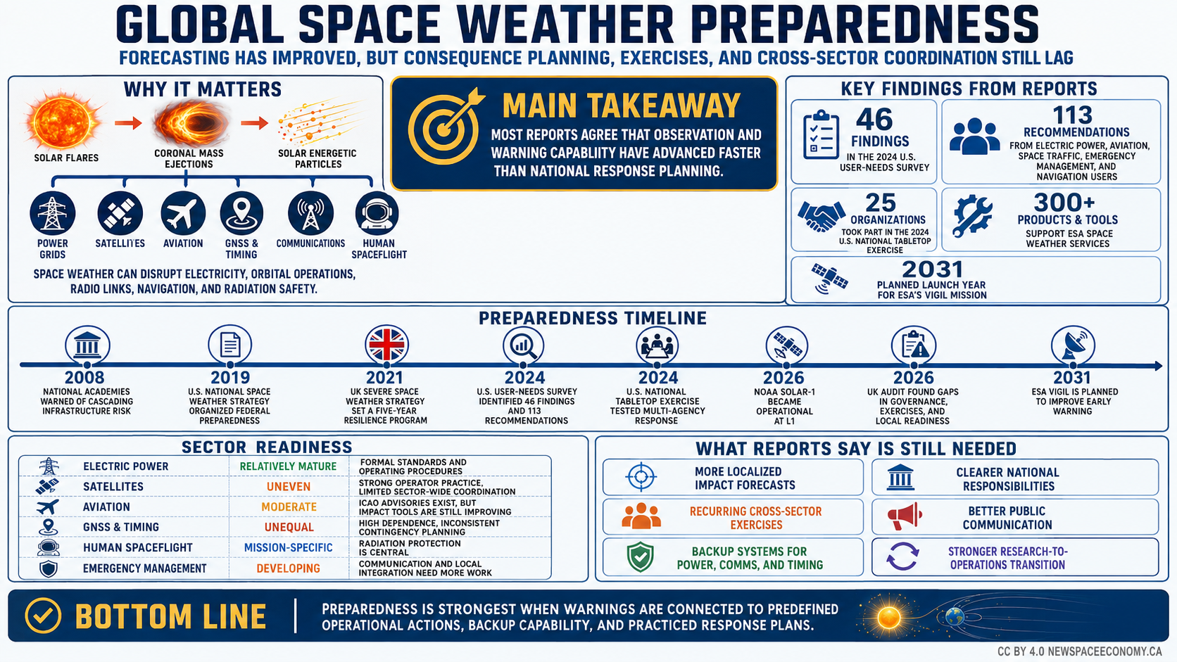
- Key Takeaways
- What Published Reports Say About Space Weather Preparedness
- Why Forecasting Space Weather Is Easier Than Forecasting Its Consequences
- How the United States Built a Layered Preparedness System
- What the United Kingdom Reveals About the Gap Between Policy and Readiness
- How Other National and International Systems Are Preparing
- Why Sector Readiness Remains Uneven
- What Exercises and Real Storms Reveal About Operational Readiness
- What a More Complete Space Weather Preparedness Model Would Require
- Summary
Key Takeaways
- Forecasting has improved faster than cross-sector planning, exercises, and impact-based warnings.
- Power grids have the strongest formal safeguards, but satellite and navigation exposure is growing.
- Exercises show that role clarity and public communication determine whether warnings become useful.
What Published Reports Say About Space Weather Preparedness
On March 20, 2026, the United Kingdom’s National Audit Office published an assessment that found years of investment had strengthened forecasting but still left unclear responsibilities, incomplete cross-sector response planning, and limited exercising. The findings in the UK preparedness audit capture a recurring theme in published research on space weather preparedness: governments have made measurable progress in observing the Sun, forecasting hazardous conditions, warning operators, and protecting electric-power networks, yet consequence management remains less mature across many sectors.
Space weather describes changes in the space environment driven mainly by solar activity. Solar flares can produce bursts of electromagnetic radiation that affect high-frequency radio communications and ionospheric conditions within minutes. Coronal mass ejections (CMEs), immense clouds of magnetized solar plasma, can take roughly one to several days to reach Earth and trigger geomagnetic storms. Solar energetic particles can expose spacecraft electronics, astronauts, aviation operations, and other technology to elevated radiation. The effects differ in timing, geography, duration, and severity, which makes a single universal preparedness procedure impractical.
The scientific problem is only one part of readiness. An operational forecaster may know that a geomagnetic storm is probable, yet an electricity operator needs to know where geomagnetically induced current (GIC) may become large enough to threaten equipment. A satellite operator needs an estimate of atmospheric-density changes, radiation exposure, charging, and communications conditions. An airline needs route-specific information about radiation, navigation, and high-frequency communications. Emergency officials need expected consequences stated in terms that support decisions, rather than a scientific index alone.
That distinction has become more important as economic exposure has increased. New Space Economy’s recent examination of solar storms and space activity describes the expansion of the active satellite population and the resulting growth in orbital exposure. The hazard from the Sun is ancient, but the amount of technology depending on stable conditions in space, the upper atmosphere, and the ionosphere is much larger than it was when many national preparedness systems were designed.
Published work on preparedness can be divided into several overlapping families. National strategies assign responsibilities and establish policy priorities. Scientific assessments identify hazards, forecast limitations, and observation needs. Sector standards convert hazard information into operating requirements. Exercises test whether institutions can use warnings under pressure. User-needs studies examine whether forecasts match the decisions that operators actually make. International guidelines address data sharing, aviation, spacecraft design, and cross-border cooperation.
An early reference point for the present policy discussion is the National Academies’ 2008 workshop report, Severe Space Weather Events. It examined societal and economic consequences associated with severe storms and the dependence of technologically advanced societies on electric power, satellite services, communications, and navigation. Its importance lies less in any single loss estimate than in its systems perspective. Failures can propagate because infrastructure networks depend on one another, and restoration may depend on services degraded by the same event.
The United States subsequently moved toward a more formal national framework. The 2019 national strategy organized federal activity around protecting national and commercial assets, improving forecasts, and strengthening response and recovery. A 2023 implementation plan translated those objectives into agency actions extending across research, observations, modeling, user engagement, resilience, and operations.
Preparedness research has also shifted from asking whether space weather can cause disruption to asking what specific users require before they will change an operating decision. That shift can be seen clearly in the 2024 user-needs survey produced by the U.S. Space Weather Advisory Group. The survey reported 46 findings and 113 recommendations across electric power, aviation, human spaceflight, space traffic management and coordination, emergency management, research, and navigation users. Repeated needs included regional impact estimates, education, test environments, better archives, faster data access, automation, and products tied more directly to operational consequences.
Europe has followed a similar path. A European assessment of a coordinated space-weather approach called for national risk studies, socioeconomic assessments, stronger links between research and service users, and coordination across national boundaries. The European Space Agency (ESA) has since developed a Space Weather Service Network organized around user requirements rather than one generic forecast product. By 2026 its service environment included dozens of tailored services and hundreds of underlying products and tools for spacecraft, navigation, aviation, power, and other users.
International policy adds another layer. The United Nations Guidelines for the Long-term Sustainability of Outer Space Activities call on states and international organizations to share operational space-weather data and forecasts, develop models and mitigation practices, maintain observation continuity, and assess socioeconomic effects. The United Nations Office for Outer Space Affairs continues to support implementation through its space-sustainability repository.
The reports collectively suggest that space weather preparedness has moved through three broad stages. Early work established that severe events could affect technologically dependent societies. Later strategies built institutional structures, warning services, observation networks, and sector procedures. Current work concentrates increasingly on the last mile between forecast and decision: localized impacts, uncertainty, exercises, coordination, public communication, continuity planning, and recovery.
The table organizes influential reports and frameworks by their contribution to preparedness. It shows how the emphasis moved from hazard recognition toward operational use, exercises, and sector-level decision support.
| Year | Report Or Framework | Preparedness Contribution |
|---|---|---|
| 2008 | National Academies Workshop Report | Connected severe storms with cascading technological and economic disruption |
| 2015 | UK Preparedness Strategy | Established cross-sector national planning for severe events |
| 2019 | U.S. National Strategy | Linked forecasting, protection, response, and recovery at federal level |
| 2019 | UN Sustainability Guidelines | Promoted international data sharing, modeling, mitigation, and capacity building |
| 2021 | UK Severe Space Weather Strategy | Set a five-year national resilience program through 2026 |
| 2023 | U.S. Implementation Plan | Assigned multi-year actions across science, operations, resilience, and services |
| 2024 | U.S. User-Needs Survey | Identified 46 findings and 113 recommendations from operational users |
| 2025 | U.S. Solar And Space Physics Decadal Survey | Set research and forecast-performance goals for the coming decade |
| 2026 | UK National Audit Office Assessment | Found gaps in governance, exercising, sector assurance, and local readiness |
No single publication provides a complete international scorecard. National systems use different terminology, risk tolerances, legal structures, electricity markets, satellite fleets, aviation responsibilities, and emergency-management arrangements. Their documents nonetheless permit a meaningful comparison because the same preparedness questions recur: Is the hazard observed? Can it be forecast soon enough? Do forecasts describe expected consequences? Does a responsible organization receive them? Does that organization know what action to take? Has the procedure been exercised? Can services be restored if mitigation fails?
Space weather preparedness is mature only when the answers extend through that full chain. Published reports indicate that many countries can answer the early questions more confidently than the later ones.
Why Forecasting Space Weather Is Easier Than Forecasting Its Consequences
A solar eruption can be seen leaving the Sun long before its full terrestrial effects are known. That apparent contradiction explains much of the preparedness problem. Observation may establish that an event occurred, yet the severity, location, and timing of technological consequences can remain uncertain until the disturbance is much closer to Earth.
Different space-weather phenomena also operate on different clocks. X-rays and extreme-ultraviolet radiation from a solar flare reach Earth at the speed of light, so effects on the sunlit ionosphere can begin almost simultaneously with detection. Energetic particles may arrive within tens of minutes or several hours. A CME usually provides substantially more warning because the plasma cloud travels far more slowly than light, but its ability to generate a severe geomagnetic storm depends heavily on its speed, density, and magnetic orientation when it interacts with Earth’s magnetic field.
This leads to a fundamental difference between event forecasting and impact forecasting. A forecaster may identify an Earth-directed CME, estimate an arrival window, and classify a storm threat. An electricity operator still needs geographically specific estimates of how the disturbance may interact with regional geology, transmission-line orientation, transformer design, grid loading, and operating conditions. The same geomagnetic disturbance can produce different GIC levels in different networks.
Satellite operators face a different translation problem. Geomagnetic activity heats the thermosphere, causing the upper atmosphere to expand. Atmospheric density at low Earth orbit can rise sharply and increase drag. Operators need to predict how quickly density will change at their particular orbital altitude and inclination, then update orbital predictions and maneuver plans. New Space Economy’s review of the May 2024 Gannon storm describes how density changes and widespread spacecraft maneuvers complicated orbital prediction during an already difficult operating period.
Radiation adds another set of user requirements. Spacecraft designers need cumulative and event-specific radiation environments. Operators may need thresholds for switching components off, postponing operations, changing spacecraft orientation, or placing systems in protective modes. Human-spaceflight organizations need estimates tied to crew dose and available shielding. Airlines need information appropriate to flight altitude, latitude, route, and duration.
Navigation users face conditions in the ionosphere rather than the direct arrival of a CME at a receiver. The Global Navigation Satellite System (GNSS) depends on precisely timed radio transmissions traveling from satellites to receivers. Disturbed ionospheric electron density changes propagation time and can increase positioning error, degrade integrity, or cause loss of tracking. The operational meaning differs for a smartphone, precision agriculture, maritime navigation, survey equipment, aircraft, autonomous systems, and timing-dependent telecommunications.
These differences help explain a recurring finding in user-needs research: users often want impact information rather than another scientific parameter. NOAA’s Space Weather Prediction Center (SWPC) already provides standardized scales for geomagnetic storms, solar radiation storms, and radio blackouts. Those scales support broad awareness, but an operator deciding whether to alter a flight, modify grid configuration, postpone a spacecraft maneuver, or change a launch timeline needs more context.
The 2024 Space Weather Advisory Group survey found repeated demand for greater regionalization. Electric-power users wanted improved regional GIC estimates and better model validation. Aviation users wanted clearer tools for radiation, communications, and navigation risk management. Human-spaceflight users wanted improved radiation information, operational policy support, and accessible historical data. Space traffic users emphasized neutral-atmosphere density because drag affects orbital prediction and conjunction assessment.
A second recurring need was testing. Operators often cannot wait for an extreme event to learn whether a forecast product works inside their workflow. Testbeds, historical archives, simulated data, replay capability, and exercises allow organizations to evaluate thresholds and procedures before a storm occurs. This is one reason the user-needs report treated education and test environments as cross-cutting requirements rather than optional outreach.
Data access matters for the same reason. A forecast that arrives too slowly for automated systems may have limited operational value even if it is scientifically sound. Archives that are difficult to search impede model validation and post-event analysis. Inconsistent interfaces create additional work for commercial operators integrating information into software. The preparedness problem consequently extends from scientific measurement through data engineering and operational design.
The 2025 National Academies survey describes research outcomes that would materially expand warning capability. Among the longer-term objectives are improved flare forecasting, earlier solar energetic particle forecasts, better estimates of CME properties and magnetic structure, and improved thermospheric-density forecasts during geomagnetic storms. These are scientific goals rather than promises of present performance.
Observation location also determines warning time. Spacecraft near the Sun-Earth L1 Lagrange point can sample the solar wind before it reaches Earth, but the remaining interval can be short. Remote sensing from other viewpoints offers the prospect of earlier characterization. ESA’s Vigil mission, planned for launch in 2031, is designed to operate near the fifth Lagrange point and view solar activity from the side, supplementing observations along the Sun-Earth line.
The United Kingdom’s 2026 audit illustrates the present limit. The National Audit Office reported that forecasters may warn of geomagnetic-storm onset roughly 18 hours to four days ahead, yet accurate intensity estimates may remain unavailable until approximately 30 minutes before arrival. Solar-radiation-storm warning can be shorter, and radio-blackout effects can begin with little practical advance notice.
That difference matters for emergency planning. A national government may have time to convene officials after a CME is identified but still lack confidence about which regions or sectors will experience the greatest effects. Operators may need to prepare for a range of outcomes, then narrow actions as the event approaches. Policies that assume a precise long-range forecast can create false confidence.
Preparedness consequently depends partly on designing decisions that tolerate uncertainty. Operators can identify low-cost steps appropriate at an early warning stage, reserve disruptive actions for stronger evidence, and establish thresholds for escalating protection. Such tiered procedures resemble approaches used for terrestrial hazards, but space weather adds the complication that a single solar event can affect electricity, aviation, satellites, communications, navigation, and human spaceflight through different physical mechanisms.
More accurate forecasts remain valuable, but scientific improvement alone cannot eliminate the need for contingency planning. Even an excellent forecast cannot decide how much electric load an operator should redistribute, whether a spacecraft should defer a maneuver, how an airline should manage a polar route, or what message a government should issue to the public. Those decisions depend on engineering, economics, institutional authority, risk tolerance, and the consequences of unnecessary protective action.
How the United States Built a Layered Preparedness System
The U.S. preparedness structure combines federal strategy, scientific research, operational forecasting, observation spacecraft, industry standards, emergency-management doctrine, user consultation, and exercises. No single agency owns the entire problem. That distributed architecture reflects the fact that space weather affects systems regulated, operated, or studied by different federal departments and private organizations.
The 2019 National Space Weather Strategy and Action Plan established three broad federal objectives: improve protection of national security, homeland, and commercial assets; develop and disseminate more accurate and timely forecasts; and establish plans for responding to and recovering from severe events. The 2023 implementation plan moved from those broad objectives toward assigned actions across the federal government.
Federal Strategy and Agency Responsibilities
The Space Weather Operations, Research, and Mitigation (SWORM) framework coordinates federal activity. NOAA supplies operational forecasting through SWPC. The National Aeronautics and Space Administration (NASA) supports heliophysics research and space missions. The National Science Foundation supports research and ground-based observing capabilities. The Department of Defense operates systems with substantial space-weather exposure. The Federal Emergency Management Agency (FEMA) addresses national preparedness and response. Other departments become involved according to their missions and infrastructure responsibilities.
The Promoting Research and Observations of Space Weather to Improve the Forecasting of Tomorrow Act, generally known as the PROSWIFT Act, formalized parts of this arrangement and created the Space Weather Advisory Group (SWAG). The group supplies independent advice representing user communities and has become an important mechanism for identifying gaps between what the federal enterprise produces and what operators need.
Federal preparedness also includes an operating concept for an impending event. The federal operating concept directs departments and agencies supporting national essential functions to monitor space-weather notifications and incorporate the hazard into preparedness planning. It distinguishes preparation before an event from actions triggered by a warning and from reporting of preparatory measures.
That is an important institutional step because infrequent hazards are vulnerable to organizational forgetting. A severe storm may occur years after the official who wrote a plan has changed jobs. Operating concepts, continuity procedures, training, automated notification, and recurring exercises reduce dependence on individual memory.
The federal structure also recognizes that an event can last from hours to days and may create cascading consequences. An electricity disturbance can affect telecommunications. Communications loss can interfere with emergency coordination. Navigation degradation can complicate transportation and timing. Satellite problems can degrade weather, communications, Earth observation, or other services used during a terrestrial response.
Observation and Forecasting Infrastructure
Preparedness depends on observing the Sun and the near-Earth environment continuously. NOAA, NASA, the U.S. Geological Survey, universities, international partners, and other organizations contribute data from space and the ground. New Space Economy’s guide to space-weather monitoring provides broader internal context on how solar activity is observed, classified, and communicated.
A significant operational change occurred in 2026. NOAA’s Space Weather Follow On-Lagrange 1 spacecraft, subsequently designated SOLAR-1, became operational on June 10, 2026. NOAA describes it as a spacecraft dedicated to continuous operational space-weather observation at L1. Its instruments include a coronagraph for imaging CMEs, a magnetometer, and solar-wind and suprathermal-ion instruments.
The NOAA SOLAR-1 status page listed the spacecraft as operational by August 2026. NOAA’s coronagraph capability provides imagery designed for operational forecasting rather than depending solely on aging research missions. Redundancy and continuity are important because loss of an upstream observing spacecraft during a severe solar event would reduce exactly the information operators need most.
Geostationary Operational Environmental Satellites also contribute space-weather observations. Ground magnetometer networks measure disturbances that help estimate geomagnetic conditions and GIC exposure. Solar telescopes, ionospheric measurements, radiation sensors, and other instruments supply complementary information because no single observation describes every hazard.
The strongest observation system can still have a preparedness weakness if data continuity is uncertain. National and international reports repeatedly call for overlapping missions, backup capability, ground networks, calibration, archives, and open access. Long procurement cycles for spacecraft mean that replacement planning must begin well before an existing mission reaches end of life.
User Requirements and Operational Products
The 2024 SWAG survey is one of the clearest attempts to measure preparedness from the perspective of users rather than producers. Its 46 findings and 113 recommendations show that the remaining work is highly sector-specific.
Electric-power organizations asked for improvements in regional impact modeling, ground observations, validation, and operational integration. Aviation organizations identified needs involving radiation, high-frequency communications, GNSS, education, and products better matched to flight decisions. Human-spaceflight organizations emphasized radiation forecasting, mitigation, data accessibility, and policy. Space traffic users emphasized density forecasting because geomagnetic heating changes satellite drag.
Emergency managers face a different problem. Their expertise lies in coordinating consequences rather than interpreting heliophysics. They need messages that identify likely service disruptions, affected areas, timing, uncertainty, protective measures, and responsible agencies. A geomagnetic index without consequence information may be scientifically precise but operationally weak for that audience.
This issue was reinforced by the U.S. space-weather tabletop exercise held on May 8 and 9, 2024. The exercise brought together 25 federal, state, tribal, territorial, and local organizations under sponsorship from NOAA, NASA, the National Science Foundation, and FEMA. A March 2025 after-action report, summarized by Johns Hopkins APL, called for more understandable impact-based notifications, stronger coordination among federal and subnational authorities, national education, and coordinated public messaging.
The timing gave the exercise unusual relevance. The May 2024 Gannon geomagnetic storm occurred during the event, turning an exercise scenario into a period of real elevated solar activity. That coincidence provided a reminder that plans cannot assume that scientific staff, emergency officials, infrastructure operators, and public communicators will have separate problems to solve. They may need to work from the same developing information at the same time.
Electric-Grid Standards
Electric power has one of the most formalized space-weather preparedness regimes in the United States and Canada. Long transmission lines can act as conductors for GIC generated by changes in Earth’s magnetic field. Those quasi-direct currents can enter transformers through grounded neutral connections, create heating, increase reactive-power demand, distort waveforms, activate protective equipment, and contribute to voltage instability.
The Federal Energy Regulatory Commission and the North American Electric Reliability Corporation (NERC) developed mandatory requirements addressing geomagnetic disturbances. NERC’s GMD operating standard requires operating plans, processes, and procedures intended to reduce adverse effects. Transmission-planning standards require specified assessments against benchmark geomagnetic events.
The approach matters because it translates a physical hazard into engineering and operating obligations. Utilities do not need to begin from a blank page whenever SWPC issues a warning. They can monitor geomagnetic information, review network conditions, assess transformer exposure, adjust operations under predefined procedures, and gather event data for later analysis.
A Government Accountability Office assessment in 2018 found uncertainty around the severity of the national grid risk but documented federal and industry measures intended to address it. That uncertainty has not disappeared. Geological conductivity, system design, transformer characteristics, network topology, storm direction, and operational conditions all affect outcomes.
The May 2024 event supplied valuable operational data. NERC’s Gannon storm review, published in 2026, reported the highest peak GIC in its database since collection began in 2013. Measurements exceeded 90 amperes in five of six NERC regions represented in the dataset, and a Wisconsin location recorded 175.7 amperes shortly after 02:03 UTC on May 11, 2024.
The absence of a continent-wide blackout during such conditions is evidence that grid planning and operating procedures can reduce risk, but it does not establish that every plausible storm can be handled without significant consequences. The May event supplied data for model validation, operating-plan review, and comparison against benchmark assumptions. Preparedness improves when real events are treated as engineering tests rather than proof that stronger events are harmless.
Research-to-Operations Transition
The U.S. system also faces the long-standing problem of turning research advances into dependable operational services. A model can perform well in an academic study without being ready for continuous use. Operational systems require documented performance, reliable inputs, software maintenance, computing capacity, validation, cybersecurity, user support, backup arrangements, and procedures for communicating uncertainty.
The 2025 National Academies decadal survey recommended an organized space-weather program and set ambitious scientific objectives for the coming decade. More capable forecasting of solar flares, energetic particles, CME magnetic properties, and thermospheric density could give operators more time or greater confidence. The benefit depends on those advances reaching operational systems and products that users can interpret.
Commercial providers add another layer. Companies now offer space-weather data, analytics, radiation products, satellite-drag information, and enterprise-risk services. New Space Economy’s discussion of commercial space-weather services describes how public data can be combined with specialized analytics for operators, insurers, utilities, and other customers.
Commercial services can supplement government capability but cannot substitute easily for public warning responsibilities. A national warning system must serve government agencies, public infrastructure, small operators, and communities that may not purchase specialist services. Public observations also form much of the data base on which private products depend.
The U.S. system is consequently best understood as layered rather than centralized. Research improves knowledge. Observations provide data. NOAA produces operational warnings. sector organizations translate hazards into procedures. FEMA coordinates consequence planning. SWAG gathers user requirements. Exercises test coordination. Private firms add specialized products. The preparedness challenge lies in keeping those layers connected as technology and exposure change.
What the United Kingdom Reveals About the Gap Between Policy and Readiness
The United Kingdom offers an unusually well-documented case because it has published national strategies, operates a dedicated forecasting center, funds new observing capability, includes severe space weather in national risk planning, and has subjected its preparedness to independent audit. The resulting record shows substantial institutional progress alongside persistent weaknesses in governance and consequence planning.
The government published a national space-weather preparedness strategy in 2015 covering electricity, transport, satellite navigation and timing, telecommunications, and central and local government. A replacement 2021 preparedness strategy set a five-year vision extending through 2026.
The 2021 document organized activity around assessing the risk, preparing for disruption, and responding and recovering. It committed the government to work with industry, academia, and international partners. The Met Office Space Weather Operations Centre supplied operational forecasting, and the United Kingdom invested in domestic scientific capability and international observation programs.
The independent assessment released by the National Audit Office in March 2026 found that this activity had improved forecasting and understanding but had not produced an equally complete national response system. Severe space weather had appeared on the National Risk Register since 2011, yet responsibilities across government remained insufficiently clear in important areas.
The audit reported that the government had not established a defined target level of resilience or an explicit risk appetite for severe space weather. Without such a target, departments and infrastructure operators can undertake preparedness work without a common measure of how much disruption the country expects them to withstand.
This is a broader problem in low-frequency, high-impact hazards. Absolute protection would be extremely expensive and may be technically impossible. Governments normally need to decide what level of service degradation is acceptable, which services require priority protection, how long disruption may last, and how scarce resources should be allocated. A strategy that calls for greater resilience without establishing expected performance leaves difficult choices unresolved.
The National Audit Office also found incomplete visibility into sector response plans. Central government could identify work occurring across important sectors but did not have a sufficiently complete view of how those plans would interact under a severe nationwide event. The distinction is significant because sectors depend on one another. An electricity contingency plan may rely on telecommunications, fuel delivery, positioning and timing, or staff transportation that are themselves disrupted.
Exercise frequency was another weakness. Plans can appear coherent on paper yet fail when organizations discover incompatible assumptions, unclear authority, inaccessible contact information, unfamiliar warning products, or competing priorities. The audit called for more simulation and greater engagement with local responders and businesses.
Local preparedness presents a particular challenge because space weather is technically specialized but its consequences may appear as familiar terrestrial problems: power interruption, communications degradation, navigation errors, transport disruption, satellite-service loss, and uncertain restoration times. Local emergency officials do not need to become solar physicists. They need to know what service problems are plausible, who provides authoritative information, what public guidance is appropriate, and how national coordination will work.
Forecast limitations further complicate the UK model. The Met Office can identify an approaching geomagnetic hazard well before arrival under favorable circumstances, but the 2026 audit noted that accurate storm-intensity information may emerge only close to Earth. This creates a period in which national officials know something may happen but cannot yet describe its exact severity.
That period has operational value if plans define graduated responses. Government can place coordination centers on alert, verify contacts, confirm backup systems, brief infrastructure operators, review communications templates, and postpone nonessential activities without ordering costly or disruptive measures prematurely. As confidence rises, operators can escalate protection.
Investment has focused heavily on forecasting and observation. The National Audit Office reported expenditure of roughly £6.7 million on the Met Office Space Weather Operations Centre in 2025-26 and a UK contribution of about £300 million to ESA’s Vigil mission to date. Vigil is scheduled for launch in 2031 and is intended to provide a side-on view of the Sun from the fifth Sun-Earth Lagrange region.
That spending illustrates a policy imbalance found in several countries. Observation missions are tangible programs with defined hardware, budgets, schedules, and technical requirements. Cross-sector preparedness depends more heavily on governance, exercises, local planning, communications, continuity arrangements, and agreements among organizations. Those activities may cost less than spacecraft but are harder to measure and maintain.
The UK government stated in a July 2026 Parliamentary response that it accepted the National Audit Office recommendations and was reviewing the 2021 strategy during 2026. As of September 2, 2026, the 2021 strategy remained the published severe-space-weather strategy on the government website.
Operational capability continues in parallel with that review. The UK National Space Operations Centre, working with the Met Office and defense organizations, publishes recurring information covering orbital risks and space weather. Its July 2026 update reported functioning warning and protection services during a month with increased space-weather activity compared with June.
The UK case demonstrates that possession of a national strategy is not equivalent to demonstrated readiness. It also demonstrates the value of independent auditing. Strategies often record commitments; audits ask whether responsibilities are clear, money is connected to outcomes, response plans exist, dependencies are understood, and exercises show that the system can function.
A mature national program needs both. Without strategy, responsibilities can fragment. Without independent assessment, strategy can become a list of activities whose contribution to actual resilience is difficult to measure.
How Other National and International Systems Are Preparing
No global authority can direct every country’s response to a geomagnetic storm. Space-weather preparedness instead operates through national forecasting centers, scientific organizations, electricity-system rules, aviation arrangements, satellite operators, emergency agencies, international data-sharing agreements, and voluntary guidelines.
The resulting international picture is uneven. Some countries maintain extensive forecast services and formal infrastructure standards. Others rely on international products and concentrate on emergency planning. High-latitude states have additional incentives because geomagnetic effects can be stronger at northern or southern latitudes, although severe storms can expand the affected region considerably.
Canada
Canada’s experience is shaped by geography and the March 1989 Hydro-Québec blackout. A geomagnetic storm caused the province’s power system to collapse, interrupting electricity for roughly six million people for about nine hours. The event remains one of the most frequently cited demonstrations that a solar disturbance can produce large terrestrial consequences.
Natural Resources Canada operates the Canadian Space Weather Forecast Centre and the Canadian Magnetic Observatory System. Ground magnetometers are particularly valuable in a country spanning a large geographic area and regions with substantial geomagnetic exposure.
Preparedness extends beyond forecasting. Federal public guidance updated in February 2026 advises households to maintain emergency supplies, communication alternatives, paper maps, charged devices, fuel, and contingency plans. The government’s space-weather preparedness guidance treats the hazard partly as a potential source of familiar emergency consequences rather than asking households to interpret solar physics.
Canada has also undertaken federal resilience work addressing severe space weather and has incorporated the hazard into broader national risk-assessment activity. Public Safety Canada’s 2026-27 planning material states that an environmental scan of federal programs, policies, and capabilities concerning space weather was completed during 2024-25.
The Canadian approach is closely connected to U.S. power-system preparedness because much of the North American grid is interconnected and NERC reliability requirements cross the border. Magnetic disturbances do not stop at national boundaries, and electricity flows can transmit operating consequences across jurisdictions.
Canada’s remaining preparedness questions resemble those elsewhere: how national scientific information reaches provincial authorities, utilities, aviation, telecommunications, satellite users, and local emergency organizations; how cross-sector dependencies are tested; and how national procedures perform during an event exceeding the experience of 1989.
Australia
Australia combines forecasting, geophysical observation, national emergency management, and exercises. The Australian Bureau of Meteorology operates the Australian Space Weather Forecasting Centre, providing forecasts, warnings, alerts, and information relevant to power, aviation, communications, satellites, defense, and navigation.
Geoscience Australia contributes geomagnetic observations and modeling intended to improve understanding of GIC exposure. Local geology matters because conductivity below Earth’s surface influences induced electric fields. National modeling can consequently provide more useful information than applying a generic global storm index to every region.
In May 2024, the National Emergency Management Agency conducted Exercise Aurora, bringing government and industry participants together around a severe geomagnetic-storm scenario. Follow-up work included refining national impact assessment, testing coordination, reviewing technology capability and procedures, strengthening institutional relationships, and identifying planning gaps.
Australia’s use of a national exercise is significant because it treats space weather as a consequence-management problem rather than solely a forecasting problem. A country does not require the world’s largest domestic space program to prepare effectively. It requires authoritative warning access, infrastructure understanding, assigned responsibilities, communication paths, continuity measures, and exercises.
New Zealand
New Zealand has moved toward a hazard-specific national response model. Its National Emergency Management Agency published a national space-weather response plan under a framework for catastrophic events. The plan establishes responsibilities and arrangements for an initial national response.
The approach separates national coordination from sector and local planning. The plan makes clear that consequence management, detailed sector procedures, regional planning, and recovery require supporting work outside the central document. That division avoids pretending that one national plan can prescribe every operator’s technical response.
New Zealand also began exercising the arrangements. A national space-weather exercise took place in late 2025, followed by electricity-sector activity in 2026. The Electricity Authority reported that more than 50 organizations took part in an industry exercise examining response to a severe event.
Power-system procedures may involve temporary disconnection of parts of the grid or generation where needed to protect equipment. Such actions illustrate a difficult preparedness trade-off. A controlled short outage can be preferable to equipment damage that produces a longer restoration problem. Decisions of that kind need prior authorization, technical criteria, communication, and public expectations.
New Zealand’s model also reflects the difficulty of preparing for a hazard with limited domestic historical experience. The national response plan acknowledges that further work is needed on implications, role clarity, human capability, technology, and implementation. That candor is useful because a published plan should mark the beginning of testing and refinement rather than an endpoint.
Japan
Japan’s approach links scientific research with detailed domestic impact analysis. Researchers working through the Project for Solar-Terrestrial Environment Prediction produced Japanese space-weather benchmarks that examined severity and social effects across electricity, satellites, communications, positioning, aviation, human space activity, and daily life.
Japan began continuous 24-hour space-weather forecasting operations in December 2019 after the September 2017 X9.2 solar flare drew substantial public and institutional attention. That move reflects a familiar preparedness pattern: disruptive or highly visible events often accelerate investment, operating-hours expansion, and public awareness.
Benchmark studies are valuable because generic historical labels such as “Carrington-class event” do not automatically translate into engineering requirements. Infrastructure has changed, satellite populations have increased, GNSS dependence has expanded, electricity systems have changed, and new industries use timing services in ways that did not exist during historic storms.
Japan’s work demonstrates the benefit of scenario scales tied to domestic systems. National benchmarks can support government planning, operator testing, engineering design, insurance, and exercises even when the precise probability of an extreme event remains uncertain.
Europe
Europe combines national forecasting organizations with ESA’s regional service structure. ESA’s Space Weather Service Network groups services around operational communities and draws on specialized centers distributed across European countries.
By 2026 ESA described the network as providing 29 user-tailored services drawing on more than 300 products and tools. The ESA service documents include customer requirements, system requirements, product specifications, validation guidance, and a product catalogue. This service-engineering approach matters because it treats space weather as something delivered to defined users with stated requirements rather than simply published as scientific information.
The network serves spacecraft operations, aviation, navigation, electricity transmission, and other users. Its distributed structure can access scientific expertise across Europe, but it also creates a coordination problem. National services, ESA services, commercial providers, and sector organizations need compatible terminology and reliable data exchange.
ESA’s Vigil mission represents the observation side of this strategy. Planned for 2031, the spacecraft is intended to watch solar activity from a viewpoint near the fifth Lagrange region. ESA expects this geometry to improve warning for some solar phenomena by observing areas of the Sun before they rotate into direct view from Earth and by viewing Earth-directed disturbances from a different angle.
Vigil will not remove short-warning hazards or every uncertainty in CME magnetic structure. Its value lies in adding another observational perspective and improving continuity within a broader service system.
International Aviation
Commercial aviation has one of the clearest international operational frameworks because flights routinely cross national boundaries. The International Civil Aviation Organization (ICAO) established global space-weather services covering effects relevant to high-frequency communications, satellite communications, GNSS-based navigation and surveillance, and radiation exposure.
The ICAO space-weather manual describes a system in which designated centers maintain continuous watch and issue advisories to aviation users. International standardization matters because a flight crossing several states cannot depend on unrelated national alert formats.
Aviation also illustrates why hazard terminology must map to user decisions. Flight planners need to know whether routes, altitudes, communications methods, navigation procedures, or crew-exposure management require adjustment. Scientific severity without operational interpretation creates unnecessary uncertainty.
United Nations Framework
The United Nations does not operate a global emergency-response system for space weather, but the Long-term Sustainability Guidelines establish principles relevant to preparedness. States are encouraged to share operational data and forecasts, support continuity of observations, develop models, exchange mitigation practices, and assess national socioeconomic exposure.
A revised 2025 United Nations publication goes further in connecting space weather with spacecraft design and mission planning. It recommends considering protective modes and accounting for space-weather effects in end-of-life planning, where atmospheric drag or system anomalies can influence disposal.
The international emphasis on data sharing is important for smaller or emerging space nations. Maintaining a national solar-observation fleet is expensive. Access to shared measurements, international forecasts, open models, training, and established practices allows countries to build preparedness without duplicating every scientific capability.
The table compares representative preparedness arrangements. The entries describe the dominant mechanisms rather than every organization participating in each jurisdiction.
| Country Or Region | Main Preparedness Mechanism | Current Direction |
|---|---|---|
| United States | Federal strategy, NOAA forecasting, standards, SWAG, exercises | More localized impacts and stronger research-to-operations transition |
| United Kingdom | National strategy, Met Office forecasting, ESA investment, audit | Clarifying governance, sector assurance, exercises, and local readiness |
| Canada | Federal forecasting, magnetometers, grid standards, emergency guidance | Integrating national risk work with sector and provincial planning |
| Australia | Forecast center, geophysical monitoring, national exercises | Refining impact assessment and national coordination procedures |
| New Zealand | Hazard-specific response plan and national exercises | Building sector, regional, continuity, and recovery arrangements |
| Japan | Continuous forecasting and national impact benchmarks | Connecting research scenarios with domestic operational users |
| Europe | ESA service network, national centers, Vigil mission | Expanding user-tailored services and observation continuity |
| International Aviation | ICAO global advisory framework | Maintaining standardized operational advisories for international flights |
| United Nations | Voluntary sustainability guidelines and capacity building | Improving data sharing, mitigation practice, and national capability |
The comparison exposes a central international issue: forecasting capability and response capability need not reside in the same country. A state can use NOAA, ESA, ICAO, regional organizations, and international scientific data without owning every observation platform. The limiting factor may instead be domestic preparation for what those warnings mean.
That makes capacity building as important as additional instruments for many states. A government receiving excellent international forecasts gains little if utilities, aviation authorities, telecommunications providers, satellite operators, emergency services, and national leaders have no established procedures for using them.
Why Sector Readiness Remains Uneven
Space weather does not create one uniform technological failure. It interacts with systems through different physical mechanisms, so sector readiness depends on different engineering practices, operating procedures, regulatory structures, and warning requirements.
Electric-power networks have spent decades studying geomagnetic disturbance. Commercial satellite constellations have expanded much faster than formal international operating rules for storm-time traffic coordination. Aviation benefits from an ICAO framework, but route-level radiation and communications decisions remain operationally demanding. GNSS use has spread into sectors whose users may have limited awareness of space-weather exposure.
The table summarizes the main differences. Readiness ratings are qualitative assessments of the degree to which published standards, plans, exercises, and user requirements have been formalized rather than predictions of how a particular system will perform in an extreme storm.
| Sector | Main Exposure | Preparedness Position |
|---|---|---|
| Electric Power | Geomagnetically induced current and voltage instability | Relatively mature standards and operating procedures |
| Satellites | Radiation, charging, drag, communications, navigation | Strong operator practice but uneven sector-wide coordination |
| Aviation | Radiation, HF communications, GNSS degradation | International advisories established; impact tools still developing |
| Navigation And Timing | Ionospheric error and receiver tracking loss | High technical dependence with uneven user contingency planning |
| Human Spaceflight | Energetic-particle radiation exposure | Mission-specific controls; growing need beyond low Earth orbit |
| Emergency Management | Cascading service disruption and public uncertainty | Growing exercise activity but incomplete local integration |
Electric Power
The power sector benefits from a direct physical connection between geomagnetic disturbance and measurable electrical effects. Utilities can install GIC monitors, assess transformer response, model geoelectric fields, monitor reactive power, and establish operating procedures.
The March 1989 Hydro-Québec failure gave the sector an unmistakable operational example. Later storms produced additional data without matching its consequences. North American reliability standards now give grid operators a formal basis for planning and operating during geomagnetic disturbance.
Uncertainty remains substantial. A benchmark storm must be converted through local geology and network configuration into expected equipment stress. Aging transformers differ in design. Network topology changes. Renewable generation, power electronics, long transmission corridors, changing load patterns, and new interconnections can alter how the grid responds.
Preparedness also includes restoration. Protecting equipment is valuable because large high-voltage transformers can be expensive, specialized, and slow to replace under severe supply constraints. Grid operators consequently care about preventing equipment damage even when doing so requires short-term operational restrictions.
The sector’s relatively mature status should not be interpreted as immunity. Standards establish planning and operating expectations against defined scenarios. They cannot prove that an unprecedented event will remain within every modeled assumption.
Satellites and Space Traffic
Satellite exposure is growing in scale and complexity. Thousands of low Earth orbit spacecraft now operate in altitude regions where geomagnetic heating can increase atmospheric drag. Communications satellites, Earth-observation missions, navigation spacecraft, scientific satellites, and human-spaceflight systems face different radiation and charging environments.
Spacecraft designers can harden electronics, add shielding, select radiation-tolerant components, protect memories, provide redundancy, and include safe modes. Operators can postpone sensitive activities, alter attitudes, monitor charging, conserve power, or change maneuver schedules. These measures are often highly mission-specific.
The space-traffic problem is newer. During a geomagnetic storm, density increases can alter the orbital paths of many low-altitude spacecraft at once. Satellite operators may respond by performing orbit-raising or drag-management maneuvers. Those actions occur when atmospheric models and orbital predictions may already be less dependable.
New Space Economy’s analysis of describes how solar activity can change atmospheric drag and accelerate orbital decay. The effect is most pronounced for spacecraft operating at lower altitudes or satellites recently deployed before they reach their operational orbit.
The May 2024 event exposed a coordination challenge. Large fleets can perform autonomous or semi-autonomous maneuvers, but other operators and space-traffic systems must interpret changed orbital paths. An increase in uncoordinated movement can degrade conjunction assessment at the moment reliable orbital knowledge is most valuable.
Preparedness for satellite operators consequently requires more than radiation-resistant hardware. It includes atmospheric-density forecasting, orbit determination, maneuver coordination, space-traffic data exchange, safe-mode logic, ground-station continuity, backup communications, fuel management, and post-storm orbit recovery.
International norms remain less prescriptive here than North American electricity standards. The United Nations sustainability framework recommends incorporating space-weather effects into spacecraft design and operations, but the exact protective actions remain largely the responsibility of states and operators.
Aviation
Aircraft are protected by Earth’s atmosphere to a much greater degree than spacecraft, yet high-altitude and high-latitude operations remain sensitive to solar energetic particles, ionospheric disturbance, and radio propagation.
High-frequency radio is important over polar and oceanic regions where terrestrial communications infrastructure is limited. Solar events can degrade or block such communications. GNSS degradation can affect navigation and surveillance performance. Elevated radiation can influence route planning and occupational-exposure management.
ICAO’s advisory system gives international aviation a common source of operational information. Global centers monitor conditions continuously and issue advisories based on effects relevant to flight operations.
The 2024 U.S. user-needs survey nonetheless found demand for better operational tools, education, and data. Aviation users need to translate scientific forecasts into flight planning. A global radiation advisory may not answer the operational question for a particular route, altitude, crew, aircraft, and departure time.
Commercial decision costs also matter. A polar reroute can add fuel burn, time, crew requirements, and disruption. Operators need enough confidence to justify action without waiting until the hazard has already arrived. That makes calibrated uncertainty and route-specific products economically important.
Navigation and Timing
GNSS exposure receives less public attention than electrical blackouts but potentially reaches more day-to-day systems. GPS, Galileo, GLONASS, BeiDou, and regional navigation constellations provide positioning, navigation, and precise time to transportation, telecommunications, finance, surveying, agriculture, emergency services, and industrial systems.
Ionospheric disturbance can create positioning errors or cause receivers to lose satellite tracking. Effects may be geographically uneven and can change quickly. High-precision users can experience problems even when ordinary consumer navigation appears acceptable.
Timing deserves equal attention. Telecommunications networks, financial systems, power systems, scientific facilities, and data centers can use satellite timing as a synchronization source. A preparedness assessment focused only on whether people can use digital maps can miss more consequential dependencies.
Resilience can include multi-constellation receivers, inertial systems, terrestrial timing sources, holdover clocks, local reference networks, augmentation services, and procedures for detecting erroneous data. The appropriate mix depends on the consequence of failure.
A central challenge is that many downstream users treat GNSS as an invisible utility. They may purchase a device or service without understanding that space weather can degrade its performance. This creates a preparedness gap between specialist navigation organizations and end users whose systems quietly depend on satellite timing.
The U.S. SWAG survey treated GNSS as a distinct user community because the demand for space-weather information differs from that of satellite operators or utilities. Better ionospheric forecasts have value only if receiving equipment and operating procedures can recognize degraded conditions and respond safely.
Human Spaceflight
Human spaceflight makes radiation preparedness an immediate health and mission-planning problem. Earth’s magnetic field provides substantial protection in low Earth orbit, but crews remain exposed to energetic particles. Missions beyond low Earth orbit will spend more time outside that protective region.
Solar energetic particle events can develop quickly. Warning time may be limited compared with CME-driven geomagnetic storms. Crew procedures consequently depend on monitoring, onboard dosimetry, shielding, spacecraft design, activity planning, and the ability to move personnel into better-protected areas.
The SWAG user-needs findings call for improved radiation information, mitigation support, historical data, and clearer operational policy. These requirements will become more demanding if sustained human activity expands near the Moon, where crews cannot depend on the same geomagnetic protection available near Earth.
Preparedness for lunar missions may require forecast services integrated into extravehicular-activity scheduling, surface-habitat operations, transit planning, and emergency shelter design. Scientific uncertainty cannot be removed from mission operations, so vehicle and habitat design must provide physical protection when warning time is inadequate.
Emergency Management and Public Communication
Emergency-management organizations sit at the end of the scientific chain but at the center of consequence coordination. Their responsibility begins when a solar event threatens services used by communities, governments, transportation systems, and infrastructure operators.
The challenge is partly linguistic. Space-weather forecasters communicate through indices, storm scales, probabilities, arrival windows, and technical descriptions. Emergency officials work with expected outages, affected populations, resource needs, geographic priorities, restoration estimates, and public protective actions.
Impact-based forecasting tries to close that gap. Instead of stating only that a geomagnetic storm may reach a given scale, a warning can describe possible consequences for electricity, communications, navigation, aviation, or satellites and indicate the uncertainty around those consequences.
Public messaging requires restraint. Most space-weather events do not cause catastrophic societal disruption. Alarmist communication can reduce trust, prompt unnecessary behavior, and make later warnings less effective. Understatement creates the opposite risk.
Preparedness plans should distinguish information for specialist operators from information for the public. A utility may need detailed geomagnetic measurements and regional modeling. A household may need to know whether an electricity interruption is plausible, how long emergency supplies should last, where authoritative updates will appear, and whether ordinary communication methods may be unavailable.
The U.S. 2024 exercise and the UK 2026 audit both identify communication and cross-government coordination as unfinished work. Those findings suggest that the limiting factor during an extreme event may be less about recognizing solar activity than about synchronizing decisions among organizations that interpret the same warning differently.
What Exercises and Real Storms Reveal About Operational Readiness
Preparedness documents describe intended behavior. Exercises and real events reveal what organizations actually do.
Space weather creates a testing problem because the most damaging scenarios are rare. Operators can go years without experiencing conditions near the upper end of planning assumptions. Staff changes, software changes, grid modifications, new satellite fleets, revised emergency structures, and institutional reorganization can make an old plan obsolete even when the underlying solar hazard is unchanged.
Exercises provide a substitute for experience. They can force participants to interpret forecasts, make decisions under uncertainty, exchange information, manage public communication, coordinate across jurisdictions, and discover dependencies before a damaging event.
The United States held its inaugural end-to-end national space-weather tabletop exercise in May 2024. Twenty-five federal, state, tribal, territorial, and local agencies participated. The after-action work identified weaknesses in impact communication, coordination, education, and public messaging.
Australia’s Exercise Aurora, also held in May 2024, examined a geomagnetic storm capable of affecting satellite communications, navigation, electricity, and other essential systems. The National Emergency Management Agency used the exercise to test national coordination and identify planning gaps.
New Zealand followed with national exercising in 2025 and an electricity-industry exercise involving more than 50 organizations in 2026. These programs are valuable because they expose infrastructure dependencies that may not appear in sector-specific technical plans.
A well-designed space-weather exercise should not assume that every service fails simultaneously. Doing so can produce dramatic scenarios but poor training value. Participants should instead receive developing information, uncertain forecasts, partial degradation, regional differences, conflicting operational priorities, and changing estimates. Those conditions resemble the decisions likely to occur during a real event.
Exercises also need recovery phases. Protecting infrastructure before storm arrival receives much attention, but restoration can be equally demanding. Operators may need to inspect equipment, verify timing sources, reestablish satellite orbits, assess radiation effects, restore communications, update navigation integrity, restart loads, and explain service status to the public.
Real storms provide data that simulations cannot. The May 2024 Gannon event reached extreme geomagnetic conditions and affected auroral visibility far from usual regions. It increased thermospheric density, produced substantial GIC measurements, affected satellite operations, and gave scientists and operators a modern dataset covering a large orbital population.
For electricity operators, the event generated measurements useful for validating GIC models and operating assumptions. NERC’s later review documented elevated current measurements across much of the monitored system. The event did not create a cascading North American grid failure, which allowed operators to examine protection and operating performance without the confounding effects of widespread equipment loss.
For satellite operators, the storm produced a very different lesson. The thermosphere expanded, drag changed, spacecraft adjusted their orbits, and conjunction-assessment systems had to operate in a less predictable environment. The presence of large constellations meant that a geomagnetic storm affected orbital operations on a scale unavailable to researchers studying older events.
For forecasters, the event offered another test of arrival-time, severity, density, and impact models. A forecast system improves when predictions are compared systematically with observations rather than judged simply as correct or incorrect. Operators care about whether the error was small enough to support the decision they needed to make.
January 2026 provided another reminder that different space-weather scales can diverge. A severe solar-radiation storm reached levels uncommon in the preceding two decades, accompanied by strong geomagnetic activity. Radiation-sensitive operators had reason to examine particle conditions even where geomagnetic effects were not identical to those of May 2024.
Post-event analysis should feed directly into procedures. Utilities can compare measured GIC against models. Satellite operators can compare predicted and actual drag. Aviation organizations can examine communications and radiation products. Emergency managers can review notification paths. Forecast centers can identify where timing or severity estimates were weak.
The exercise cycle should work similarly. Scenario design tests a plan. Participants identify gaps. Agencies assign corrective actions. Procedures and training change. A later exercise tests the revised arrangement. Without that feedback process, recurring exercises can become demonstrations rather than preparedness tools.
Another lesson concerns contact networks. Space-weather plans often depend on specialist scientists who know which operator or official to call. That may work during ordinary events but becomes fragile during staff turnover or prolonged incidents. Formal notification systems, shared contact lists, redundant communications, and documented authority reduce dependence on personal relationships.
Public communication needs equal testing. Severe solar storms can attract intense media attention because auroras may become visible across large regions. Beautiful auroral displays can occur during the same event that creates operational concern for infrastructure. Governments and operators must communicate technical risk without implying that visible aurora is itself a measure of local infrastructure damage.
Social media can magnify speculation about internet collapse, months-long blackouts, satellite destruction, or other extreme outcomes. Prepared communication should explain what is known, what remains uncertain, which services are affected, what protective actions are appropriate, and where updates will be published.
Exercises should include misinformation and conflicting reports for this reason. Emergency communication during a severe storm may be competing with viral claims long before physical consequences are known.
The record from 2024 through 2026 suggests a useful shift in preparedness culture. Countries are moving from document production toward exercising actual coordination. That shift matters because organizational failure is difficult to forecast with a solar model.
What a More Complete Space Weather Preparedness Model Would Require
The published record does not support the claim that countries are unprepared for space weather. Nor does it support the opposite claim that forecasting and technical standards have solved the problem. Preparedness is strongest in specific functions and weaker across the connections among them.
A more complete model starts with observation continuity. Governments need dependable measurements of the Sun, solar wind, radiation environment, magnetosphere, ionosphere, thermosphere, and geomagnetic field. Observation plans need overlapping missions and replacement schedules so that a single spacecraft retirement does not create a large warning gap.
International data sharing should remain a default feature. Solar events are global physical phenomena, and duplicating every observation system in every state would be inefficient. NOAA, NASA, ESA, national meteorological agencies, research institutes, universities, and international organizations benefit from sharing measurements and model results.
The next layer is forecast performance. Agencies should publish measurable performance goals for event detection, arrival time, severity, regional conditions, radiation, ionospheric effects, and atmospheric density. Forecast evaluation should use the questions operators care about rather than scientific metrics alone.
Impact modeling forms another layer. GIC estimates need regional geology and network characteristics. Atmospheric-density forecasts need to become useful for particular orbital regimes. Radiation products need to reflect spacecraft and human exposure. Aviation products need route relevance. GNSS products need geographic and application context.
User engagement should become a continuous operating function rather than periodic consultation. The U.S. national user-needs survey provides a useful model because it asks sectors what decisions they make and what information is missing. Comparable work could be repeated after new missions, new satellite architectures, autonomous systems, electric-grid changes, and new aviation procedures alter user requirements.
Preparedness also needs explicit resilience targets. Governments should decide which functions must continue, which may degrade temporarily, how long backup capability should last, and what restoration priorities apply. The UK audit demonstrates the weakness created when a strategy promotes resilience without defining expected performance.
Sector plans must then connect to national plans. A utility may have excellent technical procedures but still depend on telecommunications, fuel, transportation, timing, and emergency services. A satellite operator may depend on terrestrial electricity and ground stations. An airline depends on communications, navigation, airports, weather services, and fuel logistics.
Cross-sector dependency maps can identify these relationships before an emergency. They should distinguish dependencies that fail immediately from those with backup capacity. A telecommunications facility may have batteries and generators. A timing system may have oscillator holdover. A satellite ground station may have redundant sites. Preparedness depends on knowing how long those alternatives can function.
Exercises should become recurring rather than exceptional. National exercises can occur less frequently than sector drills, but organizations should periodically test warning receipt, decision authority, technical procedures, communication alternatives, public messaging, and restoration.
Exercise design should include commercial companies. Much of the satellite, telecommunications, aviation, electricity, navigation, cloud-computing, and logistics infrastructure affected by space weather sits outside direct government operation. Government-only exercises cannot test the full consequence chain.
Local and regional authorities also need a defined place. They are unlikely to operate solar-observation networks, but they may manage shelters, medical services, traffic, public information, emergency communications, and community support after terrestrial infrastructure disruption.
A mature plan should differentiate warning stages. Detection of an eruption may trigger awareness. An Earth-directed CME may trigger preparatory coordination. Improved arrival estimates may trigger operator readiness. Near-Earth measurements may justify stronger protective action. Post-impact observations may guide restoration.
These stages let organizations act without assuming forecast precision that science cannot provide. Low-cost preparations can begin early. Higher-cost interventions can wait for stronger evidence when operationally safe.
Public communication should use the same staged approach. Early messages can acknowledge an event and explain uncertainty. Later messages can describe likely effects. During impact, communication should concentrate on actual service status and protective actions. Recovery messages should describe restoration rather than continue emphasizing solar conditions after the operational problem has shifted to infrastructure.
Supply-chain planning belongs in the preparedness model as well. Severe equipment damage is unlikely during most storms, but an extreme scenario could create demand for transformers, electronic components, satellite hardware, communications equipment, generators, fuel, and specialist personnel. Replacement inventories and mutual-assistance arrangements matter where restoration time depends on scarce equipment.
Satellite-sector planning needs greater collective attention because orbital exposure is increasing quickly. More spacecraft mean more services at risk, more orbital data to update during storms, more autonomous maneuvering, and more organizations requiring atmospheric-density information. Large constellations change the operational scale of a problem once studied mainly through individual missions.
The insurance industry can contribute by pricing accumulation exposure and requiring evidence of risk management, though insurance cannot restore a damaged transformer or recover a lost spacecraft. Risk-transfer mechanisms work best alongside engineering mitigation and business-continuity planning.
Research programs should continue to target forecast improvements with direct operational value. The National Academies’ goals for earlier flare, energetic-particle, CME, and atmospheric-density forecasts describe where additional science could produce larger decision windows.
Observation investments such as NOAA’s SOLAR-1 and ESA’s planned Vigil mission address part of that requirement. Their benefit will depend on data continuity, operational integration, model quality, and whether users can act on the information.
Preparedness metrics also need improvement. Counting strategies, meetings, forecasts, or published plans says little about operational performance. More meaningful measures include whether warnings reach designated decision-makers, how quickly agencies activate, whether models meet user thresholds, whether backup systems work, how many corrective actions from exercises are closed, and whether restoration objectives are achieved.
Independent review can test these claims. The UK National Audit Office assessment demonstrates how outside scrutiny can identify gaps that program descriptions may not reveal. Similar audits could examine whether national strategies have achieved their intended operational outcomes.
International comparisons should remain cautious because countries face different geomagnetic exposure and infrastructure structures. Still, common benchmarks are possible: observation access, 24-hour forecasting, national responsibility, electricity procedures, aviation integration, satellite guidance, GNSS contingency planning, emergency-management arrangements, public communication, exercising, and international data exchange.
Space weather preparedness will never remove the hazard. The Sun will continue producing eruptions whose exact properties cannot be known far in advance. The practical objective is to prevent a physical disturbance from becoming an unnecessarily large technological and societal disruption.
That requires a chain of capability rather than one exceptional forecast model. Observation must feed forecasting. Forecasting must feed impact estimates. Impact estimates must reach responsible organizations. Organizations must have authorized actions. Actions must be exercised. Essential services need backup capability. Recovery plans must work when prevention is insufficient.
The published reports increasingly agree on that architecture even when national implementation differs.
Summary
Global space weather preparedness is substantially more developed than it was when the National Academies examined severe-event consequences in 2008. Operational forecasting centers now work continuously in several countries. International aviation has a standardized advisory system. North American electricity operators work under mandatory geomagnetic-disturbance requirements. National strategies exist in countries including the United States and United Kingdom. Canada maintains extensive geomagnetic monitoring. Australia and New Zealand have incorporated space weather into national emergency exercises. Japan has developed domestic impact benchmarks. ESA operates a growing network of specialized services, and the United Nations promotes international sharing and mitigation practices.
Scientific capability has also advanced. NOAA placed SOLAR-1 into operations in June 2026, adding a dedicated operational observing platform near L1. ESA is developing Vigil for a planned 2031 launch. Research priorities identified by the U.S. National Academies seek longer warning windows and better predictions of CME properties, energetic particles, and atmospheric density.
Yet the published evidence does not show a fully integrated international preparedness system. Forecast accuracy varies by phenomenon. Local impacts remain difficult to predict. Some users receive scientific information that does not map directly to operating decisions. Cross-sector dependencies are incompletely tested. Local emergency organizations may have limited space-weather experience. Commercial satellite growth is changing orbital exposure faster than many older planning assumptions anticipated.
The 2024 U.S. national user-needs survey is particularly revealing because 46 findings and 113 recommendations remained after decades of research and operational forecasting. Its recommendations center on matters such as regional impact information, validation, education, archives, automation, test environments, radiation products, atmospheric density, and communication. Those are signs of a field moving from general hazard awareness toward operational refinement.
The 2026 UK audit reaches a comparable finding from a governance perspective. Investment in forecasting and international observation did not automatically produce clear responsibilities, defined resilience targets, complete knowledge of sector planning, extensive exercising, or strong integration with local responders. The government’s acceptance of the audit recommendations establishes an opportunity to address those weaknesses in its next policy cycle.
Electric power remains comparatively mature because operators have measurable physical effects, engineering models, monitoring equipment, mandatory standards, and decades of operational experience. Aviation has the advantage of an international ICAO framework. Satellite operations have substantial mission-level expertise but face rapidly increasing fleet scale and difficult storm-time orbital prediction. GNSS and timing present a quieter concern because dependence is dispersed through systems whose operators may not recognize space weather as an input risk.
Exercises conducted in the United States, Australia, and New Zealand show where preparedness is now heading. Forecasting agencies, infrastructure operators, emergency authorities, regional organizations, and commercial companies increasingly need to practice together. Such exercises expose assumptions that technical documents cannot reveal.
The strongest preparedness model emerging from the published record combines continuous observation, validated forecasts, user-specific impact products, sector procedures, defined authority, cross-sector dependency analysis, recurring exercises, backup capability, public communication, international data exchange, and recovery planning. Weakness in any link can reduce the value of the others.
A severe solar storm cannot be prevented. Many of its consequences can be reduced. The international evidence through September 2, 2026 shows that governments and industries have built substantial capability to detect and manage space weather, but readiness remains uneven and the most difficult work increasingly lies beyond forecasting itself. The decisive question is whether scientific warning can be converted into coordinated action quickly enough to protect the services on which technologically dependent societies now rely.