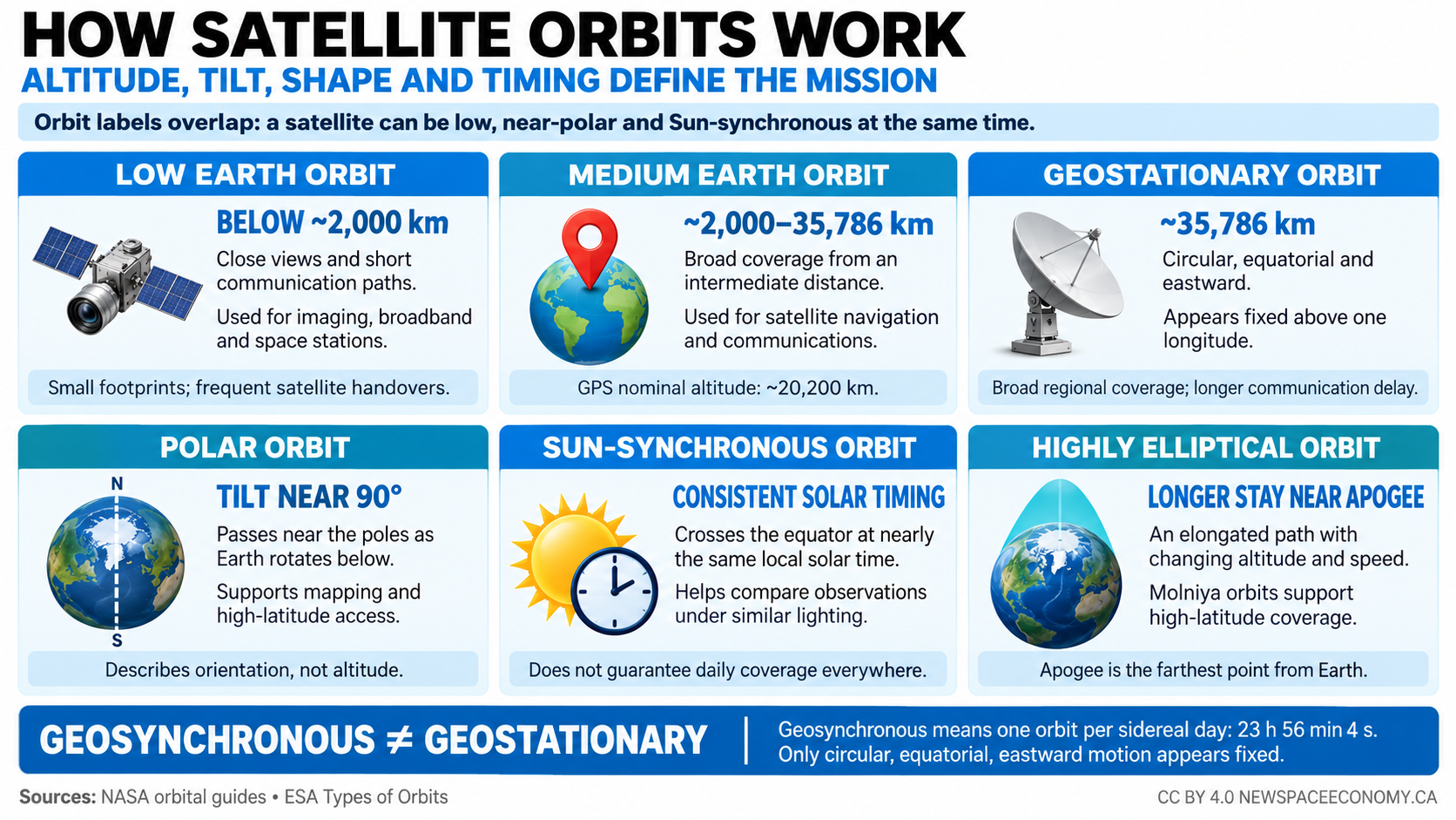
- Key Takeaways
- How the Different Types of Orbits Are Defined
- Low Earth Orbit and Very Low Earth Orbit
- Medium Earth Orbit and Navigation Constellations
- Geosynchronous and Geostationary Orbits
- Equatorial, Inclined, Polar, and Retrograde Orbits
- Sun-Synchronous, Dawn-Dusk, Repeating, and Frozen Orbits
- Highly Elliptical, Molniya, Tundra, and Regional Orbits
- Transfer, Parking, Phasing, and Escape Paths
- Lunar, Planetary, Heliocentric, and Lagrange-Point Orbits
- Constellations, Formation Flying, and Mission Architecture
- Orbit Maintenance, Disposal, and the Economics of Choice
- Summary
Key Takeaways
- Orbit classifications overlap because altitude, shape, inclination, and timing describe different properties.
- Geostationary satellites remain above one equatorial longitude; other geosynchronous satellites move in the sky.
- Choosing an orbit determines coverage, launch needs, communications delay, operating costs, and disposal options.
How the Different Types of Orbits Are Defined
A geostationary satellite circles Earth approximately 35,786 kilometers above the equator, completing a revolution in 23 hours, 56 minutes, and four seconds. A spacecraft a few hundred kilometers above Earth completes a circuit in roughly 90 minutes. These different types of orbits produce radically different views of the planet, even though the spacecraft obey the same physical laws.
The difference starts with distance and motion. An orbiting spacecraft continuously falls toward the body attracting it, but its sideways movement carries it past the surface. Gravity bends its path without requiring an engine to run continuously. The National Aeronautics and Space Administration (NASA) explains this relationship through its description of orbital free fall, which also distinguishes changing an orbit from maintaining ordinary motion along it.
Gravity remains substantial at the altitudes used by human spaceflight. Astronauts experience weightlessness because they and their spacecraft fall together, with little supporting force pressing them against the cabin. Their condition does not mean that Earth’s gravitational attraction has disappeared.
Altitude Is Only One Classification
Low Earth orbit, medium Earth orbit, and high Earth orbit describe broad distance regimes. Circular and elliptical describe shape. Equatorial and polar describe the orientation of the orbital plane, the imaginary flat surface containing an idealized orbit.
Other labels describe relationships. A geosynchronous orbit matches Earth’s rotation period. A Sun-synchronous orbit maintains a particular relationship between its orbital plane and the Sun. A transfer orbit connects different operating orbits.
These categories overlap. A satellite can occupy a low, nearly circular, near-polar, Sun-synchronous orbit at the same time. Each label contributes information, and none provides a complete description by itself.
Terminology becomes misleading when categories are treated as mutually exclusive destinations. Polar orbit is not an altitude band separate from low Earth orbit. Geostationary orbit is not a synonym for every high-altitude orbit, and an elliptical orbit need not be distant from Earth throughout its entire circuit.
The European Space Agency’s orbit classification guide introduces the principal operational families. For precise mission comparisons, those families need additional information about geometry, timing, and spacecraft purpose.
Shape, Size, and Position
An ellipse is a closed curve with two focal points. In the simplest description of a small spacecraft orbiting a much larger body, the larger body occupies one focus rather than the geometric center. A circle is the special case in which both focal points coincide.
Eccentricity measures departure from circularity. Its value is zero for a circle and lies between zero and one for an ellipse. Higher values describe more elongated ellipses, with larger differences between the nearest and farthest distances.
For an Earth orbit, the closest point is perigee and the farthest point is apogee. The corresponding general terms are periapsis and apoapsis. For an orbit around the Sun, the terms become perihelion and aphelion.
An altitude normally measures height above a reference surface. An orbital radius measures distance from the central body’s center. Confusing them creates large errors because an Earth-centered radius includes roughly 6,400 kilometers between Earth’s center and its surface.
The semimajor axis describes an ellipse’s size. It equals half the length of the ellipse’s longest diameter, or the average of the perigee and apogee distances measured from Earth’s center. It determines the orbital period in the ideal two-body model, where only the spacecraft and central body are considered.
Two ellipses can have the same semimajor axis and period but different eccentricities. One may remain at nearly constant altitude, and another may swing between much lower and higher altitudes. An orbital period alone cannot establish how close a spacecraft comes to Earth.
Inclination and the Orbital Plane
Inclination measures the tilt of an orbit relative to a chosen reference plane. For Earth satellites, that reference is usually Earth’s equatorial plane. A value of 0 degrees describes an eastward equatorial orbit, and 90 degrees describes an exactly polar orbit.
The orbital plane also has an orientation around Earth. Two satellites with identical altitudes and inclinations may occupy planes that cross the equator at different longitudes at a particular moment. Their paths can intersect even though neither follows the other.
A complete orbital description needs timing as well as geometry. Knowing an ellipse’s size and orientation does not establish where the spacecraft is along it. Mission teams specify a position or equivalent timing quantity at an identified reference time, called an epoch.
NASA’s explanation of orbital elements describes the quantities used to represent these properties. Operational systems also use position and velocity directly, together with a time reference and coordinate system.
Speed and Period Follow Physical Relationships
A spacecraft in a lower circular orbit moves faster than one in a higher circular orbit around the same body. The higher orbit takes longer to complete because its circumference is larger and its speed is lower. Within an elliptical orbit, the spacecraft moves fastest near periapsis and slowest near apoapsis.
This behavior follows the exchange between motion energy and gravitational potential energy. As the spacecraft climbs away from Earth, its speed decreases. As it falls inward, its speed increases.
An engine burn introduces an important distinction. Accelerating a spacecraft forward increases its speed immediately, but it can also raise the opposite side of its orbit. After the spacecraft reaches that higher region, its speed may be lower than it was in its original circular orbit.
Every published orbit is an approximation of a physical system. Earth’s uneven gravity field changes orbital geometry, and atmospheric drag removes energy from low satellites. The Moon and Sun also exert gravitational forces.
An “unchanging orbit” generally means a path that remains sufficiently close to its intended design. Operators can tolerate some variations and correct others. The acceptable limits depend on what the mission must accomplish.
The comparison below separates common orbit labels by the property they describe. Approximate altitude ranges are conventions rather than physical walls.
| Orbit Label | Defining Property | Important Qualification |
|---|---|---|
| Low Earth Orbit | Generally below 2,000 km altitude | Lower operating limits depend on atmospheric drag. |
| Medium Earth Orbit | Between low orbit and geosynchronous altitude | Includes several different periods and inclinations. |
| Geosynchronous Orbit | Period equals 1 sidereal day | The spacecraft need not remain fixed in the sky. |
| Geostationary Orbit | Circular, equatorial, eastward, and geosynchronous | Nominal altitude is approximately 35,786 km. |
| Polar Orbit | Inclination near 90 degrees | The term describes orientation, not altitude. |
| Sun-Synchronous Orbit | Orbital plane maintains its mean solar relationship | Consistent local crossing time does not guarantee daily revisits. |
| Highly Elliptical Orbit | Large difference between nearest and farthest distances | The spacecraft spends more time near apogee. |
Low Earth Orbit and Very Low Earth Orbit
Low Earth orbit is commonly defined as the region below approximately 2,000 kilometers, or 1,243 miles, above Earth’s surface. Its lower practical boundary depends on atmospheric drag and the spacecraft’s ability to counter it. There is no sharply defined altitude at which the atmosphere ends and long-lived orbital flight automatically begins.
The International Space Station illustrates the advantages of operating close to Earth. Its orbit lies roughly 400 kilometers above the surface, although the precise altitude changes with drag and scheduled maneuvers. The relatively short journey supports crew transport and cargo delivery.
For an uncrewed satellite, proximity can improve the strength of received communications and the detail available from an imaging instrument. It can also reduce the energy required to reach the operating orbit. Those benefits come with rapid apparent movement over the ground and limited visibility from any individual location.
A Short Orbital Period Does Not Mean Continuous Coverage
The ground track is the path traced on Earth’s surface directly beneath a spacecraft. Earth rotates under the orbital plane, so successive circuits usually pass over different longitudes. Completing an orbit in about 90 to 100 minutes does not mean returning to the same city at that interval.
A satellite becomes visible when it rises above the local horizon, but operational contact often starts later. Antennas may require a minimum elevation angle, meaning a specified angle above the horizon. Buildings and terrain can block shallow viewing directions.
The usable footprint is the region where the satellite can provide its intended service at a particular time. It is smaller than the entire portion of Earth that is geometrically visible. Antenna design and acceptable connection quality impose additional limits.
A low satellite consequently serves a moving area. Continuous communications require another spacecraft to enter view before the previous one becomes unusable, together with equipment that transfers the connection. A constellation is a coordinated group of satellites arranged to provide that repeating coverage.
Iridium’s network provides a real example of communications based on low, near-polar orbits. Its architecture uses links between spacecraft, allowing information to travel through the constellation rather than depending entirely on a ground station beneath each satellite. The orbital arrangement and the communications arrangement operate together.
Why Imaging Missions Often Fly Low
For a given optical instrument, a shorter distance generally allows finer detail on the ground. The instrument spreads its available angular resolution across a smaller surface area. A spacecraft can also use a smaller instrument to achieve a resolution that would require larger optics from farther away.
Altitude does not determine image quality by itself. Optical design and detector performance matter, and motion or atmospheric conditions can reduce useful detail. Processing can improve an image’s usability but cannot recover every feature that the instrument failed to measure.
Lower altitude also narrows the ground area seen by a fixed angular field of view. An operator seeking detailed imagery must balance resolution against the width of each observed strip, called the swath. A narrow swath can require more passes or more satellites to cover a region.
The same trade-off affects radar observations. A radar instrument transmits radio energy and measures the return, making it possible to collect information without sunlight. Its orbit still controls viewing geometry, acquisition opportunities, and the changing distance to the target.
For businesses that sell monitoring services, the useful output is not simply an image. Customers need a reliable observation at an appropriate time, followed by processing and delivery. Cloud cover can delay an optical product even when orbital access is available.
The Atmosphere Continues Into Orbital Altitudes
Thin gas at orbital height exerts drag. Each encounter removes a small amount of orbital energy, and the accumulated loss lowers the orbit. As the spacecraft descends into denser gas, decay can accelerate.
Atmospheric density changes with solar activity and geomagnetic conditions. Heating can expand the upper atmosphere, exposing satellites to more drag at the same nominal altitude. Predicting orbital lifetime requires assumptions about future conditions as well as the spacecraft’s physical characteristics.
Mass and exposed area influence the response. A compact, heavy spacecraft generally loses speed less rapidly from a given drag force than a light spacecraft with a large exposed surface. Orientation can change the area facing the flow.
Some constellations deliberately exploit differences in drag to adjust spacing between satellites. This method changes orbital timing gradually without the same type of propulsive maneuver used for an immediate velocity change. Its usefulness depends on altitude and atmospheric conditions.
Materials also face environmental exposure. Atomic oxygen can erode vulnerable surfaces in low orbit, and repeated transitions between sunlight and darkness impose temperature cycles. Protective coatings and thermal design are part of choosing an orbit that a spacecraft can survive.
Very Low Earth Orbit
Very low Earth orbit describes operations toward the lower end of the low-orbit region, often below roughly 450 kilometers. The term has no single boundary accepted for every application. Its distinguishing feature is the stronger influence of atmospheric drag.
The retired European GOCE mission demonstrated the value of flying unusually low to measure Earth’s gravity field. Its streamlined spacecraft and electric propulsion countered drag so that sensitive measurements could continue. The mission ended in 2013 after its propellant was exhausted.
A low operating altitude can provide stronger received power or finer imaging detail. However, continuous drag compensation requires propulsion capability and electrical power. A satellite that loses control can fall out of its intended operating region much sooner than one at a higher altitude.
That shorter natural lifetime has a disposal benefit. A failed spacecraft can leave orbit relatively quickly under suitable conditions, reducing the time it remains as debris. The same characteristic can shorten the period available for recovery after an equipment problem.
Air-breathing electric propulsion has been investigated as a way to collect residual atmospheric gas and use it as propellant. Such concepts must be assessed according to demonstrated performance and mission readiness. They do not remove the need to manage drag or supply power.
Human Access and Commercial Trade-Offs
Different types of orbits support different business models, and low orbit connects closely with launch frequency. Constellations may require continuing replacement launches rather than a single deployment campaign. A spacecraft’s operating lifetime influences the manufacturing and launch schedule needed to sustain service.
For human spaceflight, lower altitude reduces travel distance and supports comparatively prompt return to Earth. It also places a station within reach of vehicles designed for that destination. Raising a station’s orbit would change transport requirements and emergency planning.
Low orbit does not guarantee a cheap mission. A large fleet can require substantial spending on production and ground infrastructure. Operations teams must manage many moving spacecraft, and the service must survive individual failures without unacceptable coverage gaps.
The economic comparison consequently extends beyond launch price per kilogram. It includes the frequency of replacement and the cost of user terminals. It also includes the value of reaching locations that terrestrial networks cannot serve reliably.
Medium Earth Orbit and Navigation Constellations
Medium Earth orbit occupies the broad region between low Earth orbit and geosynchronous altitude. It contains no single preferred operating height. Missions select particular altitudes according to coverage needs, orbital period, and the space environment.
Satellite navigation provides the most familiar application. The United States’ Global Positioning System uses nominal orbits approximately 20,200 kilometers above Earth. Europe’s Galileo constellation uses nominal circular orbits approximately 23,222 kilometers above the surface, inclined by 56 degrees.
Those figures describe orbital designs rather than a current count of functioning spacecraft. A constellation can contain satellites undergoing commissioning or held in reserve. Its service status cannot be determined from the number of objects occupying similar orbits.
Coverage From an Intermediate Distance
A satellite at medium altitude sees a much larger portion of Earth than a low-orbit spacecraft. It also moves more slowly across the sky for many observers, providing longer contact periods. These characteristics reduce the number of satellites needed for some forms of continuous coverage.
The larger footprint is useful for navigation because a receiver needs simultaneous measurements from multiple satellites. Each spacecraft contributes a timing measurement that helps constrain the receiver’s position. The constellation places spacecraft in different directions so that those measurements provide useful geometry.
A basic standalone position solution normally uses at least four satellites to solve for three spatial coordinates and receiver clock error. Additional measurements can improve availability and support error checking. The number needed for a particular application can differ when external information or constraints are available.
Good visibility is not enough if all usable satellites appear close together in the sky. Measurement errors then translate into larger position errors. Designers distribute orbital planes and spacecraft positions to avoid persistently weak geometry over the intended service area.
This requirement distinguishes navigation from a communications system that needs only one usable satellite connection at a time. The navigation constellation must provide an adequate combination of viewing directions. A large individual footprint supports that requirement but does not satisfy it alone.
Semisynchronous Orbits
A semisynchronous orbit has a period equal to half Earth’s sidereal rotation period, approximately 11 hours and 58 minutes. The term describes timing rather than a fixed shape. A circular orbit with that period lies close to the altitude used by the Global Positioning System.
The relationship between orbital period and Earth’s rotation produces a repeating ground-track pattern under an idealized model. Engineers then account for gravitational perturbations and operational tolerances. The repetition helps establish predictable geometry over time.
Semisynchronous does not mean that a satellite remains over a region for half a day. The spacecraft continues moving along its orbit, and its apparent position changes. A receiver combines measurements from whichever satellites are usable at a given moment.
Other navigation systems choose different orbital periods. Matching the Global Positioning System’s period is not necessary for compatibility at the receiver level. A receiver can process information from separate constellations when its hardware and software support their transmissions.
Timing Accuracy Depends on Orbit Accuracy
A navigation satellite broadcasts information describing its clock and predicted position. The receiver uses that information together with the arrival time of the transmission. An error in the satellite’s stated position can become an error in the calculated user position.
Ground monitoring networks measure spacecraft motion and clock behavior. Updated information allows the system to maintain useful predictions. Orbit determination is a continuing operational task rather than a calculation performed only after launch.
Relativity also affects precision timing. Satellite clocks experience different gravitational conditions and speeds from clocks on Earth. Navigation systems incorporate corrections so that these differences do not accumulate into unacceptable positioning errors.
Medium altitude supports broad service coverage, but it creates engineering demands. The spacecraft must maintain accurate timing over years, and its transmissions must remain detectable by small receivers. Ground infrastructure and software are as important to service performance as the orbital geometry.
For financial networks and telecommunications, timing may matter even when position does not. A receiver installed at a known location can obtain a common time reference from satellite navigation. This connects orbital infrastructure with services that operate far from the launch industry.
Communications in Medium Earth Orbit
Medium Earth orbit also supports broadband communications. SES operates its O3b mPOWER system in this region, illustrating a commercial architecture between low-orbit constellations and geostationary systems. Its satellites move relative to ground users rather than remaining above fixed longitudes.
The intermediate distance produces an intermediate propagation delay for comparable routing. It can reduce the delay associated with geostationary links without requiring the same constellation size as a lower system. Actual application performance still depends on routing and network congestion.
Ground antennas must follow moving spacecraft or switch their beams electronically. The network must transfer connections as geometry changes. A long contact interval can make that process less frequent than in lower orbits.
An equatorial communications constellation does not automatically provide useful polar coverage. Its satellites remain over low latitudes, and Earth blocks the view from sufficiently distant regions. Orbital height extends visibility, but it cannot remove the planet from the line of sight.
Medium-altitude service design also considers demand distribution. A system serving ships and aircraft may need capacity over oceans, but the required amount changes by route and time. Antenna beams and resource allocation determine how effectively the available spacecraft capacity follows customers.
Radiation and Long-Term Residence
The region contains portions of Earth’s radiation belts. These are populations of energetic charged particles influenced by Earth’s magnetic field. Their intensity varies with location and space-weather conditions.
Electronics can experience accumulated radiation damage or individual particle events that upset operation. Shielding and component selection reduce risk, and system design can provide recovery mechanisms. Radiation exposure must be evaluated for the actual orbit rather than inferred from a broad altitude label.
Atmospheric drag is negligible for ordinary operational planning at navigation-satellite altitudes. A failed spacecraft can remain for a very long time. Disposal requires deliberate planning because waiting for the atmosphere to remove it is not a practical near-term strategy.
Orbital disturbances still accumulate. The Moon and Sun can change eccentricity and orientation over extended periods. A disposal path needs analysis over the relevant future interval, including the possibility that its geometry could later overlap active regions.
The value of medium Earth orbit rests on the balance it offers. Large footprints support global services, and long orbital periods reduce some handover demands. Maintaining accurate spacecraft positions and managing long-lived objects remain continuing responsibilities.
Geosynchronous and Geostationary Orbits
A geosynchronous orbit has a period equal to Earth’s rotation relative to distant stars. That interval, called a sidereal day, is approximately 23 hours, 56 minutes, and four seconds. It is slightly shorter than the 24-hour solar day used by ordinary clocks.
The distinction arises because Earth moves around the Sun as it rotates. After completing a rotation relative to distant stars, Earth must turn a little farther for the Sun to return to the same local direction. A spacecraft synchronized to Earth’s rotation uses the sidereal period.
Geosynchronous orbit describes this period relationship. It does not, by itself, require a circular path or an equatorial plane. A spacecraft can match the period and still move substantially relative to a ground observer.
The Additional Conditions for Geostationary Motion
An ideal geostationary orbit combines the sidereal period with a circular path directly above the equator. The spacecraft travels eastward, in the same rotational direction as Earth. Together, these conditions keep it above one equatorial longitude.
The corresponding orbital radius is approximately 42,164 kilometers from Earth’s center. Subtracting Earth’s equatorial radius gives the familiar altitude of about 35,786 kilometers, or 22,236 miles. That altitude is a consequence of the required period.
A geostationary satellite does not hover motionless in space. It moves at roughly 3.1 kilometers per second along its orbit. Its angular movement matches Earth’s rotation, making its position appear nearly fixed from the ground.
Real spacecraft depart slightly from the ideal. Operators maintain them within specified limits using stationkeeping, the maneuvers that control orbital position and orientation. Ground equipment is designed to accommodate the permitted movement.
The word “stationary” can also conceal a geographic restriction. A freely orbiting geostationary satellite must lie above the equator. It cannot remain directly over Ottawa or London using the same unpowered orbital arrangement.
A spacecraft held above another fixed latitude would require continuing forces that ordinary geostationary satellites do not provide. Such concepts belong to different engineering categories. They should not be described as routine geostationary orbits.
Why Geosynchronous Satellites Can Move in the Sky
Inclination introduces north-south movement relative to Earth’s equator. Even if the orbit is circular, the spacecraft’s projected motion over Earth does not reduce to a single fixed point. Its ground track can form a figure-eight pattern.
Eccentricity introduces changes in orbital speed. The spacecraft moves faster near perigee and slower near apogee, but Earth’s rotation remains comparatively uniform. The resulting mismatch causes east-west movement relative to the surface.
Combining inclination and eccentricity produces ground tracks whose shape depends on how the ellipse is oriented. Some have unequal loops or a more elongated appearance. A single illustration cannot represent every possible geosynchronous orbit.
Under a simplified model, the pattern repeats once per sidereal day. Natural disturbances and stationkeeping modify the exact path. Antennas serving an inclined geosynchronous satellite may need to track it rather than point permanently at one direction.
Operators can sometimes extend a satellite’s useful life by relaxing inclination control. That reduces one category of propellant use, but it changes the apparent motion seen by customers. The commercial usefulness of such operation depends on the ground equipment and service requirements.
Persistent Regional Observation
A fixed viewing direction suits weather monitoring. A geostationary imager can repeatedly observe the same large region, following the development of storms over short intervals. The United States’ GOES-R series uses this geometry for environmental monitoring.
Persistent visibility does not mean a sensor measures every location continuously. Instruments scan according to their design and schedule. Different products can have different refresh intervals, and a satellite’s field of view is not equivalent to a single instantaneous measurement.
The viewing angle becomes more oblique toward the edge of the visible Earth disk. Surface features appear compressed, and the path through the atmosphere becomes longer. Instrument performance and product accuracy can vary with that geometry.
Polar regions are particularly poorly served from the equatorial geostationary belt. Near the poles, satellites appear close to or below the horizon. Weather systems use complementary polar-orbiting observations to obtain information that the geostationary perspective cannot provide adequately.
Different types of orbits consequently support complementary weather measurements. Frequent regional images describe rapid changes, and lower polar passes provide other measurements with different spatial detail and coverage. Forecast models combine those observations rather than treating one orbit as a universal replacement.
Communications Benefits and Delay
Geostationary communications allow a fixed ground antenna to maintain a connection with a satellite at a stable apparent location. Large coverage areas support broadcasting and links to remote sites. The spacecraft can serve many terminals without requiring the continual satellite handovers characteristic of lower constellations.
Distance introduces propagation delay. Radio energy travels at approximately the speed of light, but even that speed requires measurable time over tens of thousands of kilometers. Processing and terrestrial routing add further delay.
A simple calculation shows the scale. Traveling vertically from Earth to geostationary altitude takes about 119 milliseconds, and traveling back requires another 119 milliseconds. A request-and-reply exchange using four such space legs has an idealized propagation floor near 0.48 seconds.
Real links often travel obliquely rather than vertically, making the distance longer. The geographic separation of terminals and the structure of the network also matter. The calculation is a geometric lower bound, not a claim about the measured performance of every satellite service.
Delay affects interactive applications more than one-way broadcasting. A scheduled television transmission can tolerate a fixed delivery delay differently from a real-time control system. Choosing an orbit requires understanding the application’s sensitivity to that delay.
Orbital Positions and Radio Coordination
Geostationary spacecraft share a narrow orbital region above the equator. Neighboring systems must manage potential radio interference as well as physical separation. An orbital longitude alone does not describe all the rights or operating conditions associated with a satellite network.
The International Telecommunication Union coordinates international use of radio frequencies and associated orbital resources through established procedures. National administrations and licensing authorities also have responsibilities. These arrangements do not make an orbital position equivalent to ownership of land.
Frequency and antenna design influence how closely networks can operate. Highly directional beams can reduce interference in some configurations, but coordination depends on the full technical parameters. Separate systems can share a region under agreed operating conditions.
A geostationary satellite’s business case also depends on demand within its service area. A large footprint offers access to many potential customers, but capacity must be usable where demand exists. Payload design determines whether resources can be reassigned effectively during the mission.
New Space Economy’s discussion of orbital business models connects these physical characteristics with commercial choices. The value lies in the service that a position enables, not in altitude as an isolated attribute.
Equatorial, Inclined, Polar, and Retrograde Orbits
A spacecraft can circle Earth at the same altitude as another satellite yet serve a different geographic market because its orbital plane has a different tilt. Inclination determines the range of latitudes reached directly beneath the spacecraft. It also affects launch access and the geometry of encounters with other objects.
An equatorial orbit stays above Earth’s equatorial plane. An inclined orbit crosses that plane twice during each circuit. The crossing toward the north is the ascending node, and the crossing toward the south is the descending node.
A polar orbit passes over both geographic poles when its inclination is exactly 90 degrees. Near-polar orbits approach the poles without passing directly over them. The distinction matters when a mission needs access to the highest latitudes.
Prograde and Retrograde Motion
A prograde Earth orbit has an eastward component, following the general direction of Earth’s rotation. Inclinations below 90 degrees are prograde under the usual convention. A retrograde orbit has an inclination above 90 degrees and a westward component.
An inclination of 180 degrees describes a retrograde equatorial orbit. It follows the equatorial plane but travels opposite Earth’s rotation. The same orbital altitude can support either direction, although the launch requirements differ.
A spacecraft launched eastward can benefit from the velocity already provided by Earth’s rotation. The benefit is greatest near the equator and decreases toward the poles. Launching into a retrograde orbit requires overcoming the unwanted component of that rotational motion.
The difference affects how much payload a launch vehicle can deliver. Published performance figures depend on the destination’s inclination as well as its altitude. A rocket’s capacity to a low eastward orbit should not be treated as its capacity to every low orbit.
The orbital direction also influences relative encounter speed. Two spacecraft moving in similar directions can approach one another more slowly than objects on sharply crossing paths. An assessment of collision consequences needs the relative motion, not just the speed of either object around Earth.
Inclination and Geographic Reach
For a circular orbit inclined by 51.6 degrees, the point directly beneath the spacecraft reaches approximately 51.6 degrees north and south. The International Space Station uses this inclination. Its cameras and communications systems can see beyond the point directly underneath, depending on their viewing geometry.
Ground coverage extends beyond the maximum latitude of the ground track because an instrument can look sideways. That extension comes with greater distance and a more oblique view. It should not be confused with directly overhead coverage.
A mission centered on lower latitudes may deliberately avoid a polar orbit. Keeping its passes within the intended geographic region can increase useful observation opportunities there. Global access would spend part of each orbit above regions outside the mission’s main interest.
The retired Tropical Rainfall Measuring Mission used an inclination of approximately 35 degrees to concentrate on tropical and subtropical precipitation. NASA’s Earth satellite orbit catalog explains this historical design choice. Its orbit illustrates a deliberate geographic focus rather than an inability to reach higher latitudes.
Inclination does not alone determine how often a target can be observed. Orbital height and instrument pointing also matter, and spacecraft spacing changes the result for a constellation. A claim about revisit time needs all those conditions.
Why Polar Orbits Support Mapping
Earth rotates beneath a polar orbital plane. Each pass can observe a different strip of longitude, gradually building coverage of the surface. An appropriately designed instrument can turn that sequence into repeated global maps.
Coverage is still subject to swath width and sampling. A narrow instrument may leave gaps between successive ground tracks. Filling those gaps can require additional days or coordinated satellites.
Passes converge at high latitudes because lines of longitude converge toward the poles. This can produce more frequent viewing opportunities there than near the equator. The practical benefit depends on the instrument’s pointing limits and the mission’s operating schedule.
Polar geometry is useful beyond optical imaging. It supports observations of ice and measurements of Earth’s magnetic environment. Communications systems can also use near-polar planes to reach locations that equatorial systems cannot serve effectively.
The poles are not continuously visible to one low-orbit spacecraft. It passes through the region and moves away. Continuous polar service requires a constellation or a different orbit with longer residence above high latitudes.
Launch-Site Geometry
A launch begins at a particular latitude on a rotating Earth. Without a substantial change of direction, the launch site limits which orbital inclinations are directly accessible. An eastward launch from a higher latitude cannot simply enter a lower-inclination equatorial orbit without additional maneuvering.
Launch direction is also constrained by public safety. Rocket stages and debris must not fall across unacceptable areas. Coastal geography and flight-range rules can favor some orbital directions and restrict others.
A dogleg maneuver changes the launch path to satisfy geographic or safety constraints. It consumes performance that might otherwise carry payload. The best launch site for one orbital family may be poorly suited to another.
These relationships help explain why polar missions and equatorial missions often use different launch corridors. The distinction is physical and operational. It cannot be reduced to the price advertised for a vehicle.
New Space Economy’s analysis of launch access constraints describes the wider commercial implications of needing a particular destination and schedule. Available payload capacity on an incompatible flight does not solve an operator’s access problem.
Changing Planes After Launch
An orbital plane change redirects the spacecraft’s velocity. Even when speed remains approximately constant, changing its direction requires propulsion. Large changes can consume substantial propellant.
Performing the maneuver where orbital speed is lower can reduce the required velocity change. This is one reason some missions combine plane changes with high-altitude portions of transfer orbits. The full trade-off includes the cost of reaching that altitude.
Small satellites sharing a launch usually accept broadly similar orbital planes. They may later adjust altitude or spacing, but moving into a substantially different plane can exceed their propulsion capability. Rideshare compatibility requires more than fitting physically on the same rocket.
Constellation designers sometimes exploit natural differences in the rate at which orbital planes rotate. Satellites temporarily placed at different altitudes can accumulate separation over time. This approach trades waiting time against propellant and requires careful prediction.
The practical choice is made before hardware is complete. An orbit incompatible with the intended launch service can force a redesign or a new launch contract. Inclination belongs in mission planning from the beginning.
Sun-Synchronous, Dawn-Dusk, Repeating, and Frozen Orbits
Sun-synchronous orbit describes a controlled relationship between an orbital plane and the Sun. The plane gradually rotates around Earth at approximately the rate needed to follow Earth’s annual motion around the Sun. This preserves nearly the same mean local solar time when the satellite crosses the equator in a given direction.
The spacecraft does not remain above one place. It continues circling Earth rapidly, and the planet rotates below. The synchronization concerns solar timing, not a fixed geographic position.
For Earth observation, this relationship makes measurements easier to compare. Images collected at similar local times have more consistent lighting than observations taken at unrelated hours. The benefit is useful for detecting change without confusing it with differences in shadows.
Earth’s Shape Supplies the Plane Rotation
Earth is slightly flattened at the poles and wider at the equator. That shape changes its gravitational field from the simplest model of a perfectly symmetric body. One effect is a gradual rotation of the orbital plane, called nodal precession.
Mission designers can choose altitude and inclination so that this natural precession has the desired rate. At common Earth-observation altitudes, Sun-synchronous orbits are slightly retrograde and near-polar. The exact inclination depends on the orbit’s size and eccentricity.
The required annual plane rotation is approximately one degree per day. It is not created by flying once around Earth each day. A satellite can complete many circuits daily as its orbital plane slowly changes orientation.
Stationkeeping can be necessary because the real environment differs from the design model. Drag alters orbital size, and changes in size affect precession. Maintaining the desired crossing time can require adjustments over the mission’s life.
Sun-synchronous behavior is not exclusive to Earth. A spacecraft around another suitably shaped rotating body can use a related mechanism. The required values differ because the body’s gravity field and year are different.
Consistent Local Time Does Not Mean Identical Conditions
Local solar time describes the Sun’s position relative to the location, rather than the civil time shown on a clock. Political time zones and daylight-saving rules do not determine the orbit. A satellite’s local crossing time can remain consistent as it passes over different countries.
An ascending equator crossing and a descending crossing usually occur on opposite parts of the orbit. Their local times differ by roughly 12 hours. A mission may describe its orbit using either crossing, so the direction must be specified when comparing designs.
Seasonal changes remain. The Sun’s elevation at a location varies during the year even at the same local solar time. Clouds and atmospheric conditions also change.
Consistent timing reduces one source of variation rather than eliminating all variation. Scientific processing still corrects or accounts for illumination and viewing geometry. An observation taken in winter cannot automatically be interpreted as equivalent to one taken in summer.
The Copernicus Sentinel-2 design combines a Sun-synchronous orbit with an altitude of approximately 786 kilometers and a wide imaging swath. Its design demonstrates how orbit and instrument characteristics are selected together. The altitude alone does not explain the mission’s coverage.
Revisit and Repeat Cycle Are Different
A repeat ground-track orbit returns to approximately the same path over Earth after a specified number of revolutions and Earth rotations. The repeat cycle describes that geometric recurrence. It does not necessarily equal the shortest interval between useful observations of a target.
An instrument can view a target from a neighboring path by pointing away from directly below. That can shorten access time, but it changes the viewing angle. Some applications accept the difference more readily than others.
A constellation can also shorten revisit time by placing satellites at different positions. The Sentinel-2 mission was designed around coordinated spacecraft to provide frequent land observations. Its service characteristics result from the combination of the spacecraft arrangement and instrument swath.
A Sun-synchronous satellite does not necessarily pass over every city every day. Its ground track can take longer to repeat, and the instrument may not observe everything visible during each pass. Descriptions that equate Sun synchronization with daily global imaging overstate what the orbit guarantees.
Cloud-free revisit is another measure. An optical spacecraft can have a scheduled opportunity without obtaining a usable view of the surface. Statistical cloud conditions can create substantial differences between geometric access and delivered information.
Dawn-Dusk Orbits
A dawn-dusk orbit is a Sun-synchronous arrangement whose orbital plane lies near the boundary between Earth’s day and night sides. The spacecraft crosses the equator near morning and evening solar times. Its geometry can provide long periods of sunlight.
That illumination can simplify parts of the power system. Solar arrays may generate electricity for much of the orbit, reducing some battery demands. The exact eclipse pattern still depends on altitude and seasonal geometry.
Dawn-dusk does not guarantee permanent sunlight in every implementation. Earth’s axial tilt changes the relationship between the orbital plane and the shadow. Engineers calculate eclipse duration across the entire mission rather than relying on the category name.
The lighting over the surface can be less suitable for some optical observations. Long shadows may obscure features or change their appearance. Radar missions are less dependent on reflected sunlight, although their spacecraft still need power and thermal management.
Solar illumination also changes spacecraft temperature. A design receiving long, uninterrupted sunlight must reject heat appropriately. A power advantage can create a separate thermal requirement.
Frozen Orbits
A frozen orbit is designed so that selected orbital characteristics vary only slightly under important natural disturbances. The term usually concerns features such as eccentricity or the orientation of the nearest approach. It does not mean that the satellite stops moving.
An appropriate combination of inclination and ellipse orientation can reduce long-term changes caused by the central body’s gravity field. The details depend on that field. An arrangement useful around Earth does not automatically work around the Moon.
Small variations remain because a real spacecraft experiences more influences than the simplified design includes. A frozen orbit reduces maintenance needs within a defined model. It does not promise indefinite operation without correction.
For mapping, keeping the altitude pattern consistent can improve the comparability of observations. Predictable geometry also helps instrument scheduling and data processing. The operational value lies in reduced variation in the features that matter to the measurement.
Repeating and frozen are separate properties. An orbit can be designed to approximate both, but satisfying one does not automatically satisfy the other. Sun synchronization adds another requirement that may be combined with them.
Sampling Can Be More Valuable Than Uniform Lighting
A mission studying the daily cycle of rainfall may need observations at changing local times. Keeping every pass at the same hour could leave part of that cycle poorly sampled. A non-Sun-synchronous orbit can deliberately provide a different measurement pattern.
NASA’s Global Precipitation Measurement mission combines observations from an international group of satellites to study precipitation. Its measurement strategy illustrates the importance of considering how time sampling supports a scientific objective. Uniform solar timing is useful for some measurements and restrictive for others.
The choice among these types of orbits depends on the quantity being measured. A land-change record benefits from consistent viewing conditions, and a study of daily atmospheric variation needs time diversity. The observing schedule must match the scientific question.
Highly Elliptical, Molniya, Tundra, and Regional Orbits
A spacecraft in a highly elliptical orbit spends much more time near its distant end than near Earth. The reason is the changing speed along an ellipse. Slow movement around apogee can create extended visibility above a selected part of the planet.
This makes an elongated orbit useful for missions that do not need uniform global coverage. A carefully oriented ellipse can concentrate useful observing or communications time over high latitudes. Other portions of the orbit may contribute little to the primary service.
The phrase “highly elliptical” describes shape. “High Earth orbit” describes distance. Both are sometimes abbreviated with the same letters, so spelling them out avoids ambiguity.
Apogee Dwell and Regional Service
Apogee dwell is the extended interval during which a spacecraft remains near its farthest distance. Its motion never stops, but the combination of slow speed and viewing geometry can keep it useful to a region for hours. Antennas still need to accommodate changing position.
The location of apogee matters as much as the ellipse’s shape. An orbit with apogee above the Northern Hemisphere provides a different service pattern from one with apogee above the Southern Hemisphere. The ellipse’s orientation determines which region benefits.
A highly elliptical satellite can rise much higher in the sky at northern locations than a geostationary satellite does. That reduces some obstruction problems associated with viewing close to the horizon. It also changes the atmospheric path traversed by the radio transmission.
Continuity usually requires more than one spacecraft. As a satellite leaves the useful portion of its orbit, another must become available. The constellation’s spacing and handover timing determine whether the regional service remains uninterrupted.
Molniya Orbits
A classical Molniya orbit combines an approximately half-sidereal-day period with high eccentricity and an inclination near 63.4 degrees. It is associated historically with Soviet communications satellites designed to serve high northern latitudes. Its elongated shape allows long residence near northern apogee.
The inclination has a useful gravitational property. In a simplified model dominated by Earth’s equatorial bulge, it suppresses the main secular rotation of the ellipse’s line of apsides, the line joining perigee and apogee. This helps keep the high-altitude portion favorably oriented.
That property does not eliminate all orbital change. Additional gravity terms and the attraction of other bodies still affect the spacecraft. Operators must assess the complete environment.
The perigee lies much lower than the apogee, so the spacecraft crosses a large range of distances during each revolution. Its speed and communications geometry change accordingly. The engineering design must support both the long service interval and the rapid lower-altitude passage.
Molniya should not be used as a label for every eccentric satellite above the Northern Hemisphere. Its classical period and inclination distinguish it from other families. Missions can also adopt modified designs when their specific requirements justify different values.
Tundra Orbits
A Tundra orbit is an inclined, eccentric geosynchronous orbit with a period of one sidereal day. It can provide an extended daily presence over a chosen region. Its ground track differs from the pattern produced by a half-day Molniya orbit.
Classical Tundra designs are often associated with inclination near 63.4 degrees, but the service concept depends on several orbital parameters together. Eccentricity determines the degree of uneven residence time. The orientation of the ellipse places the long dwell over the intended region.
The distinction between Tundra and geostationary is direct. Both can share the same orbital period, but Tundra motion is inclined and eccentric. A fixed ground antenna suitable for an ideal geostationary satellite may not support a Tundra spacecraft.
A one-day period also changes constellation scheduling. The spacecraft returns through its ground-track pattern once per sidereal day. A continuous service design must account for the portions of that pattern that provide insufficient elevation or coverage.
The broader lesson is that equal periods do not imply equal service. A circular equatorial spacecraft and an eccentric inclined spacecraft can repeat on the same schedule yet offer different geographic advantages. Period, shape, and orientation must be considered together.
Quasi-Zenith Orbits
Japan’s Quasi-Zenith Satellite System uses regional orbital geometry to improve satellite positioning availability. Its architecture includes inclined geosynchronous spacecraft, together with geostationary elements. The system demonstrates a practical use of one-day orbits that are not all stationary.
“Zenith” means the direction directly overhead. A quasi-zenith design keeps spacecraft at high elevation over the intended service region for extended intervals. This helps in locations where buildings or mountains obstruct low-elevation satellites.
The spacecraft does not remain directly above one Japanese city. It follows a repeating path shaped to favor the region. A coordinated constellation supplies the desired availability over time.
Regional positioning systems can complement broader navigation constellations. They do not need to reproduce the global geometry of medium-altitude systems. The design priority is strong service over an identified area.
This is a useful distinction between geographic reach and geographic emphasis. A satellite may be visible over a broad region but spend its most valuable observing time above a narrower one. Service commitments depend on the detailed coverage model rather than the largest possible footprint.
Scientific Uses of Eccentric Orbits
An elongated orbit can help a scientific mission sample different parts of the space environment. A spacecraft may pass through changing particle populations or magnetic conditions during one revolution. The variation becomes part of the measurement rather than an inconvenience.
Astronomical observatories can also benefit from spending long intervals far from Earth. Greater distance can reduce interruptions from Earth blocking a target. Mission teams still account for radiation exposure and the need to return data.
Around other planets, eccentric orbits can balance close measurement opportunities against environmental hazards. NASA’s Juno mission used elongated polar orbits at Jupiter to combine close passes with long excursions away from the planet. Its orbit design interacted directly with the radiation environment and scientific objectives.
A close approach provides brief access to fine spatial detail. The distant part can support different measurements or communications activities. An orbit that seems inefficient for continuous surface mapping can be well matched to another scientific purpose.
Costs of Extreme Altitude Variation
Changing distance affects received radio power. Ground and spacecraft systems must support the weakest expected link, often near the distant end. Antenna tracking also becomes more demanding when apparent motion accelerates during closer passages.
Radiation exposure can differ sharply along the orbit. Repeated passages through hazardous regions may impose cumulative damage. Avoiding a long residence in one region does not necessarily mean a low total dose.
Thermal conditions and eclipse durations can change with orbital geometry. Power storage must cover the periods when sunlight is unavailable. An orbital configuration that offers strong regional coverage may create difficult battery requirements.
Disposal also requires attention to the entire ellipse. Leaving an inactive spacecraft with a low perigee and high apogee can expose multiple orbital regions to repeated crossings. A responsible end-of-life plan needs to control where the object travels, not just where it spends most of its time.
Transfer, Parking, Phasing, and Escape Paths
A satellite’s launch orbit often differs from its operating orbit. Rockets and spacecraft can divide the work of reaching the final destination. The intermediate paths are selected according to propulsion capability, launch geometry, and mission timing.
A parking orbit is a temporary orbit used before another maneuver. It can provide time for checkout or allow departure at a suitable point in the orbital cycle. The term describes its operational purpose rather than a special altitude or shape.
A transfer orbit connects different orbital conditions. It may link two Earth orbits or carry a spacecraft toward another body. Some transfers are brief, and others involve months of gradual change.
Delta-V and the Cost of Maneuvering
Delta-v means change in velocity. Mission planners use it to describe the propulsion needed to change speed or direction. It is a measure of maneuvering requirement rather than a direct measure of travel distance.
The same distance can involve very different delta-v requirements. Moving between nearby but sharply inclined orbital planes can be expensive. Traveling much farther along a favorable gravitational path can require less propulsion.
Propellant consumption depends on the propulsion system as well as delta-v. An efficient engine can produce the same total velocity change using less propellant, but it may deliver low thrust. That can extend the time needed to complete the maneuver.
A spacecraft’s propulsion budget also includes later tasks. Stationkeeping and collision avoidance consume resources after arrival. Reserving enough capability for disposal can reduce the amount available for operational extensions.
Hohmann Transfers
A Hohmann transfer connects two coplanar circular orbits through an ellipse tangent to both. An initial maneuver places the spacecraft on the transfer ellipse. A later maneuver at the opposite end matches the destination’s circular speed.
For a transfer outward, the initial burn increases speed and raises apogee. At apogee, another forward burn raises perigee until the orbit becomes circular at the destination. Reversing the process can lower a circular orbit.
This arrangement is efficient under a defined set of assumptions. It is not automatically the best transfer for every mission. Different time limits or orbital geometries can justify another approach.
NASA’s description of Hohmann transfers extends the concept to travel between planetary distances. Reaching another planet also requires correct timing because the planet moves during the journey. Arriving at its orbital distance does not guarantee an encounter.
Geostationary Transfer Orbits
A geostationary transfer orbit is typically an ellipse with a low perigee and an apogee near geostationary altitude. A launch vehicle can deliver a satellite into this orbit without supplying all the energy needed for final circularization. The satellite then completes the remaining maneuvers.
The spacecraft may also need to reduce inclination. Launching from a site north or south of the equator generally leaves a plane adjustment to be completed. Combining that adjustment with a high-altitude maneuver can improve efficiency.
A payload figure “to geostationary transfer orbit” is incomplete without the transfer conditions. Different perigees and inclinations leave different amounts of work for the satellite. Two launches carrying the same mass can deliver substantially different remaining propulsion requirements.
Supersynchronous transfers place apogee above geostationary altitude. The lower speed near that high apogee can make a plane change less expensive. Later maneuvers bring the spacecraft into the desired circular orbit.
This approach trades one set of requirements against another. A higher apogee takes more energy to reach, and the satellite must follow an appropriate sequence to arrive correctly. It cannot be evaluated from maximum altitude alone.
Electric Orbit Raising
Electric propulsion accelerates propellant using electrical energy. Many systems use less propellant for a given total delta-v than conventional chemical systems, but produce much less thrust. A satellite can raise its orbit gradually rather than relying only on short, powerful burns.
The resulting path can resemble an expanding spiral rather than one simple transfer ellipse. Maneuvers occur over many revolutions, and the orbit changes continuously. Operational constraints can interrupt thrusting to support power or thermal limits.
Saving propellant can reduce launch mass or allow more payload. A longer transfer can delay the start of commercial service. It may also increase the time spent passing through radiation regions.
An operator must evaluate the full financial effect. Lower launch mass has value, but so does earlier revenue. Insurance arrangements and commissioning schedules may depend on how the orbit-raising phase is designed.
Phasing and Rendezvous
Phasing orbits change a spacecraft’s arrival time at a future location. By entering an orbit with a slightly different period, a vehicle can gain or lose position relative to another spacecraft. It later returns to the desired orbit when the timing is correct.
Rendezvous requires matching position and velocity. Passing through the same point at high relative speed is not a usable meeting. A servicing vehicle or crew capsule must approach under controlled relative motion.
The geometry can be counterintuitive. A vehicle that needs to catch a spacecraft ahead may enter a lower orbit, where it completes revolutions more quickly. Returning to the target’s altitude at the correct time then permits the approach.
Final proximity operations use more than an overall orbit model. They require precise relative measurements and procedures for safe retreat. A successful transfer into the target’s orbital region does not itself establish readiness for docking.
Gravity Assists and Low-Energy Transfers
A gravity assist uses an encounter with a moving celestial body to change a spacecraft’s motion relative to another reference, usually the Sun. The spacecraft exchanges a tiny amount of momentum with the body. Its direction changes during the encounter, and its solar-relative speed can increase or decrease.
The effect does not create energy without an exchange. In an ideal encounter, the spacecraft’s speed far from the body can remain the same in that body’s reference frame. The change becomes apparent when the motion is measured relative to the Sun.
Low-energy transfers exploit the combined gravity of multiple bodies. They can reduce certain propulsion requirements, often by accepting longer travel times or more constrained launch opportunities. Their paths are not adequately described by one fixed Earth-centered ellipse.
The Cislunar Autonomous Positioning System Technology Operations and Navigation Experiment used a prolonged transfer before entering its lunar operating orbit in November 2022. NASA’s mission description records the completed demonstration and the conclusion of NASA’s activities in June 2026. The flight provides a concrete example of using time and natural gravitational behavior to support a small spacecraft mission.
Escape and Suborbital Flight
A parabolic path represents the ideal boundary between bound and unbound motion in a two-body model. A hyperbolic path has greater energy and does not return to the central body in that simplified description. Real interplanetary flight still includes the gravitational influence of other bodies.
Escaping Earth does not necessarily mean escaping the solar system. A departing spacecraft commonly enters another orbit around the Sun. Its Earth-relative and Sun-relative classifications can differ.
Suborbital flight reaches altitude without establishing a path that remains clear of Earth. Its unpowered path intersects the atmosphere or surface. Reaching a recognized boundary of space does not supply the sideways velocity needed for sustained orbit.
Lunar, Planetary, Heliocentric, and Lagrange-Point Orbits
The words “low,” “polar,” and “elliptical” remain useful beyond Earth, but their numerical meaning changes. A low lunar orbit lies above a much smaller body with weaker gravity. A polar orbit around Jupiter encounters a magnetic and radiation environment unlike Earth’s.
An orbit must always be described relative to a central body or a clearly stated reference system. A spacecraft can be bound to the Moon and also participate in the Earth-Moon system’s motion around the Sun. These descriptions answer different questions about the same physical movement.
The two-body approximation works well for some purposes and poorly for others. Near a planet, its gravity can dominate short-term motion. Farther away, the combined influence of other bodies becomes too important to treat as a small correction.
Low Lunar Orbits
Low lunar orbits support close surface mapping and access for landing missions. Their short distance can provide detailed observations and reduce the travel required between orbit and the surface. The Moon blocks direct communication with Earth during portions of many such orbits.
Lunar gravity is uneven because mass is distributed unevenly inside the Moon. Concentrated mass anomalies can change an orbit’s shape and lower its nearest approach. A path that appears safe in a simple model can require correction in the real environment.
NASA’s Lunar Reconnaissance Orbiter demonstrates the scientific value of close lunar observation. Its mission has produced extensive information about the surface and environment. The spacecraft’s operating geometry must be considered alongside its instruments when interpreting coverage and resolution.
A low orbit is not always the best place to store a spacecraft between surface missions. Maintenance requirements and access geometry can favor other arrangements. The shortest distance to the surface does not automatically minimize the total propulsion needed by an entire architecture.
Distant Retrograde and Halo Families
A distant retrograde orbit around the Moon appears to move opposite the Moon’s motion in a reference frame rotating with the Earth-Moon system. This wording matters because orbital direction depends on the selected frame. The path draws support from the combined gravitational system rather than behaving like a small circular orbit close to the Moon.
Some members of this family offer favorable stability characteristics. They can require relatively little maintenance compared with less favorable paths. Their distance from the surface can increase the transportation required for landing and ascent.
Halo orbits belong to another family of three-dimensional motion associated with the combined gravity of two larger bodies. They are normally described in a rotating reference frame. Their looping appearance does not mean that an invisible massive object sits at the center of each loop.
A near-rectilinear halo orbit is a particular family with an elongated appearance and close passages near the Moon. The name describes its geometry within the Earth-Moon system. It should not be treated as an ordinary lunar ellipse whose orientation remains fixed without Earth’s influence.
NASA’s lunar orbit demonstration tested this operating environment with a small spacecraft. Such demonstrations help determine the propulsion and tracking needed to maintain the intended path. They also test whether predicted communications and positioning methods work in flight.
Lagrange Points
Lagrange points are five special locations in the idealized rotating system formed by two large bodies. A sufficiently small object can remain at a fixed relative location there under the appropriate conditions. The gravitational forces provide the acceleration needed to rotate with the system.
They are not generally places where gravity becomes zero. A spacecraft still experiences gravitational attraction. The useful balance is defined in a rotating reference frame.
The points labeled L1, L2, and L3 lie along the line connecting the larger bodies. The other two form equilateral-triangle arrangements with them. Their labels refer to positions in a particular system, so Sun-Earth L2 and Earth-Moon L2 are different locations.
The collinear points are unstable in the simplified model. A spacecraft near them generally needs corrections to remain within its intended operating region. The triangular points can be stable under suitable mass-ratio conditions, but real disturbances still require analysis.
Sun-Earth L1 and L2
Sun-Earth L1 lies roughly 1.5 million kilometers from Earth toward the Sun. It provides a useful location for monitoring the Sun and the solar wind before that material reaches Earth. The exact warning interval depends on the speed and structure of the approaching disturbance.
Sun-Earth L2 lies roughly the same distance beyond Earth on the side away from the Sun. It offers a geometry in which the Sun and Earth remain in broadly similar directions as seen from a nearby spacecraft. This is useful for observatories that must shield sensitive instruments from heat and light.
The James Webb Space Telescope’s orbit uses a large loop around the Sun-Earth L2 region. The observatory orbits the Sun together with Earth and completes its L2 loop in roughly six months. It does not sit motionless at the mathematical point.
That geometry supports thermal protection and a favorable observing environment. The spacecraft still has pointing constraints and scheduled communications. A distant observatory cannot view every target at every time.
New Space Economy’s coverage of space-weather preparedness connects upstream monitoring with operational needs on Earth. The value of an observing location depends partly on how quickly measurements reach the organizations that can act on them.
Halo and Lissajous Motion
A halo orbit is a three-dimensional periodic solution in an idealized rotating model. A Lissajous orbit combines motions that generally do not close into one repeating loop. Both can be used near Lagrange-point regions.
Real spacecraft follow controlled paths that depart from ideal mathematical solutions. The gravity field contains more bodies, and small disturbances accumulate. Mission teams select a practical operating corridor and correct deviations when needed.
The size of the loop affects communications and shadow avoidance. Remaining away from direct alignment can keep a spacecraft out of eclipses or reduce interference from the Sun in a ground antenna’s view. The point itself is only part of the design.
These types of orbits demonstrate why a list based solely on altitude becomes incomplete. A spacecraft’s useful location can arise from relationships among several moving bodies. The reference frame becomes part of the description.
Heliocentric and Planetary Orbits
A heliocentric orbit is centered on the Sun. Earth occupies one, and many spacecraft enter heliocentric motion after departure. A spacecraft can lead or trail Earth without remaining gravitationally bound to it.
Reaching the inner solar system requires changing the motion inherited from Earth. A spacecraft already travels around the Sun before launch because Earth does. Reducing its solar angular momentum can be more demanding than the short-looking distance on a diagram suggests.
NASA’s Parker Solar Probe used repeated Venus encounters to reshape its solar orbit and achieve close approaches to the Sun. Its flight illustrates the value of gravity assists for reaching a demanding orbit. Distance alone would be an inadequate measure of mission difficulty.
Planetary arrival often requires an insertion maneuver that makes the spacecraft bound to the destination. A flyby and an orbiter can visit the same planet with different propulsion requirements. An orbiter must remove or redirect enough relative motion to remain.
Where an atmosphere exists, aerobraking can gradually reshape an already captured orbit through repeated atmospheric passes. NASA’s Mars Reconnaissance Orbiter used this approach to reach its mapping orbit. The method conserves propellant but requires careful management of heating and atmospheric uncertainty.
Constellations, Formation Flying, and Mission Architecture
A single orbit describes one spacecraft’s motion. A constellation describes how multiple spacecraft are arranged to deliver a combined service. The architecture adds orbital-plane spacing and timing relationships to the properties of each individual orbit.
Placing many satellites at the same altitude does not automatically create continuous coverage. They could occupy nearly the same part of the sky and leave long gaps elsewhere. Useful service requires deliberate distribution.
The number of spacecraft is also an incomplete measure of capacity. Payload performance and ground infrastructure influence how much service can be delivered. A larger constellation can still perform poorly if its capacity does not align with demand.
Orbital Shells and Plane Spacing
An orbital shell is a group of orbits within a specified range of altitudes and inclinations. A constellation may use multiple shells for different coverage or capacity needs. The term does not describe a solid structure or a physical lane.
Within a shell, spacecraft occupy several orbital planes. The planes are rotated relative to one another around Earth, and satellites are distributed along each plane. Their combined arrangement determines how viewing opportunities change with time.
Designers use mathematical patterns to distribute spacecraft systematically. Walker constellations are one familiar family of arrangements based on inclination, plane count, and relative phasing. The pattern provides a starting point that still needs testing against operational requirements.
At high latitudes, some inclined planes bring satellites closer together in geographic coverage. This can increase availability but also concentrate service capacity where demand may be smaller. A constellation designed for global reach can have a different commercial efficiency from one focused on populated latitudes.
Spacing must also account for failures. The network may need enough overlap to preserve acceptable service when a spacecraft is unavailable. Spare capacity has a cost, but inadequate redundancy can make individual failures visible to customers.
Coverage and Capacity Are Different
Coverage means that a location can obtain a usable connection or observation opportunity. Capacity describes how much service the system can deliver. A satellite can cover a large area without having enough resources to serve every potential user there simultaneously.
For communications, available bandwidth and power limit throughput. Antenna beams divide those resources geographically. A system with excellent geometric coverage can still experience congestion over busy regions.
For Earth observation, the equivalent constraint may be acquisition capacity. Instruments require power and storage, and they may need time to turn between targets. A satellite cannot necessarily collect every image that its orbit makes geometrically possible.
Delivery adds another constraint. A collected image may remain onboard until a suitable downlink opportunity. The time from observation to customer receipt can matter more than the revisit interval advertised for the spacecraft.
A complete performance claim should identify the service being measured. “Global coverage” can refer to eventual access, continuous connectivity, or a defined sampling interval. Those meanings are not interchangeable.
Ground Systems Complete the Orbit
A ground station receives data and sends commands when the spacecraft is accessible. Its latitude and antenna capabilities affect the contact opportunities. Polar-orbiting satellites can have frequent access to stations at high latitudes because their paths repeatedly approach those regions.
A network of ground stations reduces dependence on any one site. It can shorten the time between data collection and delivery. Weather and local infrastructure can still affect availability.
Inter-satellite links provide another path. A spacecraft can forward data to another satellite that has a suitable ground connection. The benefit depends on link capacity and the geometry between spacecraft.
Optical links use light and can support high data rates with narrow beams. Their pointing requirements are demanding, and ground optical links face cloud constraints. Radio and optical systems can be combined according to the mission’s needs.
The ground network also supports orbit determination. Measurements of range and motion update predictions of where spacecraft will be. Better position knowledge improves scheduling and reduces uncertainty in collision assessments.
Formation Flying
Formation flying coordinates the relative motion of spacecraft that operate together. Their absolute orbits may look similar, but their separation and orientation serve a measurement or operational purpose. The formation can extend the capabilities of instruments distributed across multiple vehicles.
Relative positions do not remain fixed automatically. Small differences in orbital period cause spacecraft to drift apart along the path. Gravity disturbances and drag differences can change separation in other directions.
Control strategies depend on how tightly the formation must be maintained. Some missions permit predictable relative motion, and others require much closer regulation. Propellant use and measurement accuracy influence the practical limit.
A formation is distinct from a constellation whose members operate mostly independently. Both involve multiple spacecraft, but their coordination requirements can differ substantially. The terminology should follow the physical relationship and mission purpose.
Multi-Orbit Services
A service can combine low and high spacecraft rather than relying on one altitude regime. A lower layer may provide short communication paths, and a higher layer may provide broad coverage or relay access. Ground equipment and network control must support the transitions.
The arrangement does not erase the limitations of its components. A terminal needs compatible antennas and frequencies, and the network must decide when to use each path. Switching can introduce operational complexity even if it improves availability.
For government users, combining orbital layers can reduce dependence on a single architecture. It can also complicate procurement and verification. Service requirements need to specify performance across the combined network rather than assume that more layers automatically improve every measure.
Commercial users may care primarily about delivered availability and price. The underlying orbit becomes important when it changes latency or installation requirements. An effective service description connects the orbital design to those measurable outcomes.
Deployment and Replacement
A constellation reaches its intended arrangement through a deployment sequence. Satellites may begin together and use small period differences to spread along their orbit. Distributing them among separate planes can require more time or launch opportunities.
An operator must decide when a partially deployed network can begin useful service. Some architectures produce coverage gradually, and others need a minimum arrangement before the service meets its requirements. The deployment plan affects the timing of revenue and customer commitments.
Replacement spacecraft must reach the correct part of the network. Launching a spare into an accessible orbit is not sufficient if it cannot join the required plane. The difference between available launch capacity and suitable launch capacity becomes commercially significant.
Maintenance of the architecture continues after deployment. Failed satellites create gaps, and planned retirements require replacements. The operating orbit is part of a continuing transportation and manufacturing program rather than a one-time destination.
Orbit Maintenance, Disposal, and the Economics of Choice
An orbit changes throughout a mission, and the spacecraft’s obligations continue after its useful payload stops working. Mission design must account for both realities. The most attractive operating location can become an expensive choice if it requires excessive maintenance or leaves no credible disposal option.
The relevant disturbances differ by orbit. Atmospheric drag dominates some low-altitude planning, and solar or lunar gravity becomes more important farther away. Solar radiation pressure, the small force produced by sunlight, can also affect spacecraft motion.
A satellite’s physical design changes its response. Large surfaces can increase drag or sunlight pressure. Propulsion and attitude control, the systems that determine where the spacecraft points, must work together when those effects matter.
Stationkeeping and Orbit Knowledge
Stationkeeping keeps an orbit within acceptable operating limits. It can maintain a geostationary longitude or preserve the timing of an Earth-observation path. The required accuracy comes from the mission rather than from a universal standard.
A maneuver uses propellant and can interrupt service. It can also change the predicted location enough to require updated planning by other operators. Timely sharing of revised orbital information helps prevent avoidable uncertainty.
Orbit determination estimates current motion from measurements. Prediction extends that estimate into the future using a model of relevant forces. Uncertainty grows when measurements are sparse or disturbances are poorly known.
A cataloged orbit should not be treated as an exact future path. Position estimates have uncertainty, and that uncertainty changes with time. Close-approach analysis must evaluate the possible range of locations rather than compare only two thin lines.
Tracking capability also differs with distance and object size. Small debris may be too difficult to monitor individually. Avoiding every hazardous object through maneuvering is not possible.
Collision Avoidance
A conjunction is a predicted close approach between objects. It does not necessarily mean a collision will occur. Operators examine the estimated separation and uncertainty before deciding whether a maneuver is justified.
The quality of the estimate matters as much as the nominal distance. A very small predicted miss with well-understood geometry differs from an uncertain encounter. Decisions must also consider the consequences of the avoidance maneuver itself.
Moving a spacecraft away from one predicted encounter can create another. Screening the proposed new orbit is part of the process. Operators may need to coordinate when both objects can maneuver.
Constellation size increases the volume of operational decisions. Automation can support screening and planning, but the underlying observations must remain reliable. A large number of satellites cannot compensate for poor knowledge of where they and nearby objects will be.
The European Space Agency’s debris guidance treats prevention and disposal as central parts of limiting future risk. Avoiding collisions during operation addresses only part of the problem. Abandoned hardware can remain hazardous long after a mission ends.
Reentry From Low Earth Orbit
Lowering perigee allows atmospheric drag to remove orbital energy more rapidly. A spacecraft can use propulsion to accelerate that process or rely on natural decay where conditions permit. The predicted time depends on the orbit and physical design.
A controlled reentry targets the final descent toward an intended region. It requires functioning systems and sufficient maneuvering capability. The vehicle’s construction influences how much material might survive to lower altitudes.
An uncontrolled reentry lacks that final targeting control. Predictions become more precise as descent approaches, but atmospheric uncertainty limits long-range precision. The fact that a spacecraft will eventually reenter does not establish that its disposal plan meets the applicable requirements.
Design for demise seeks to make components more likely to break up and burn during atmospheric entry. It must be balanced against the strength and thermal requirements of the operating mission. Disposal engineering starts before launch, when materials and component placement can still be changed.
Natural decay can be useful at low altitudes, but it is not a universal cleanup mechanism. Objects higher in the low-orbit region can persist much longer than objects only a few hundred kilometers above Earth. A broad low-orbit label does not establish a short residence time.
Graveyard and Disposal Orbits
Geostationary spacecraft commonly move above the protected operating region at the end of service. The destination is often called a graveyard orbit. Its separation must account for future orbital variation rather than a single final altitude measurement.
The maneuver does not destroy the spacecraft. It reduces interference with active operations by moving the object into a less disruptive region. Long-term debris prevention still matters there.
Passivation reduces stored energy that could later cause fragmentation. It can involve managing remaining propellant and batteries. An inactive object with pressurized systems or other energy sources can create debris if those systems fail.
Medium-altitude disposal requires different analysis. Natural gravitational effects can alter eccentricity over long periods, changing the object’s nearest and farthest distances. A disposal plan must consider those future changes and the regions occupied by active spacecraft.
A spacecraft cannot always be placed in its preferred disposal orbit after an unexpected failure. Reliability of the disposal system is part of responsible design. Reserving propellant has little value if the vehicle cannot use it when needed.
Servicing and Orbital Accessibility
Inspection or life extension requires a servicing vehicle to reach the client’s orbital conditions. Similar altitude alone does not ensure an economical meeting. Plane alignment and timing can dominate the required propulsion.
A servicing business consequently has a geographic equivalent in orbital mechanics. Customers clustered in compatible orbits may be easier to serve than customers spread across strongly different planes. The address of a satellite includes motion.
New Space Economy’s discussion of in-space servicing markets examines the relationship between technical access and commercial demand. Compatible interfaces and clear operating arrangements are also needed. Reaching a client is only one component of providing a repeatable service.
Debris removal presents additional difficulty when the target cannot cooperate. The object may tumble and provide no communications. Capture and disposal must avoid creating further fragments.
Servicing can extend useful operations, but it does not make all satellites economical to repair. A small replacement spacecraft may cost less than a dedicated rendezvous mission. The comparison changes with the client’s value and orbital accessibility.
Evaluating the Full Mission Cost
Choosing among types of orbits requires a full-life assessment. The launch contract is one expense, and spacecraft design is another. Ground equipment and the workforce needed for continuing operations can substantially change the result.
A distant communications satellite may serve a large region with few spacecraft but require more powerful payloads. A lower constellation may reduce propagation delay but require repeated replacement launches. Neither architecture can be judged from spacecraft count alone.
Insurance also depends on the phases and hazards of the mission. A long orbit-raising period presents a different exposure from direct insertion. Coverage terms and commercial acceptance reflect technical reliability as well as the consequences of failure.
Government procurement can place different values on the same orbit. A scientific mission may prioritize measurement quality, and a communications customer may prioritize availability during disruption. Requirements must identify the intended outcome before comparing costs.
The workforce spans more than flight dynamics. Ground-network specialists and payload engineers contribute to orbital service performance. Licensing and financial planning influence whether the chosen design can be deployed and maintained.
Matching an Orbit to a Measurable Requirement
A useful selection process begins with a measurable service requirement. For Earth observation, that might be an accepted resolution and maximum delivery time. For communications, it might be availability and end-to-end delay over a defined geographic area.
The assessment then tests whether the spacecraft and ground system can meet that requirement throughout expected conditions. Seasonal lighting and equipment failures belong in the analysis. Favorable performance during one ideal pass is insufficient.
End-user equipment can determine whether an orbital advantage becomes usable. A moving constellation requires terminals that can follow it, and an imaging product requires processing that customers can interpret. Access to a spacecraft does not automatically become an adopted service.
A credible comparison also includes the end of the mission. The selected orbit must be reachable and operable, with an achievable exit plan. Those requirements shape propulsion reserves and can influence the initial spacecraft design.
Summary
An orbit description can be understood as a compact specification of motion rather than a simple destination. Altitude determines distance, but shape determines how that distance changes. Inclination determines geographic reach, and timing relationships determine how the view repeats relative to Earth or the Sun.
The different types of orbits answer different operational needs. Low orbits support close observation and short communication paths. Medium orbits provide broad coverage for positioning and communications, and geostationary orbits provide a nearly fixed regional perspective.
Polar and Sun-synchronous describe properties that can coexist with an altitude category. Highly elliptical paths concentrate useful residence over selected regions. Transfer orbits move spacecraft between operating conditions, and multi-body orbit families provide useful locations beyond ordinary Earth-centered motion.
No orbit category guarantees a complete service. The instrument must obtain the intended measurement, the communications system must deliver it, and the ground network must make it usable. A constellation’s geometry matters only in combination with the hardware and operating plan.
The distinction between access and dependable service becomes more important as orbital infrastructure expands. A launch can place a spacecraft in the correct region without establishing the coverage or reliability promised to customers. Those outcomes require verified performance over time.
Orbit names also need precise qualifiers in public descriptions. “Geosynchronous” should not imply a fixed position, and “Sun-synchronous” should not imply daily observation of every location. “Global coverage” needs a stated time interval and service definition.
The most useful question for a mission is the connection between orbital behavior and the intended result. A scientifically productive orbit can be commercially unsuitable, and an efficient communications orbit can be poorly suited to detailed mapping. The correct choice emerges from the measurement or service that must be delivered.
That choice remains active throughout the spacecraft’s life. Operators maintain the useful geometry and respond to changing conditions. They must also preserve the ability to leave the operating region safely when the mission ends.