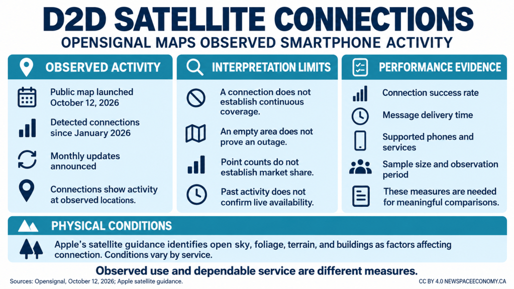
Opensignal launched its D2D Satellite Map on October 12, 2026, adding a public record of detected smartphone connections to satellites. According to the company’s launch announcement, the map identifies locations where direct-to-device connections have occurred since January 2026 and will receive monthly updates. The development gives the telecommunications industry another way to examine actual use as satellite services become available through consumer phones.
The distinction between an observed connection and promised coverage determines the map’s practical value. A recorded connection shows that a device connected at a particular location during the observation period. It does not establish that every eligible phone can connect there at any time, or that a message reached its destination. Operators, regulators, and analysts need those distinctions when assessing whether satellite services address gaps in conventional mobile networks.
Direct-to-device, often shortened to D2D, describes satellite links that reach compatible consumer devices without a separate satellite broadband terminal. The map’s explanatory material describes services intended to complement terrestrial mobile networks. It also notes that available functions remain constrained by spectrum, satellite and handset hardware, and developing standards. A connection supporting a short message cannot automatically be treated as evidence of unrestricted internet access, voice calling, or video service.
Opensignal reports that commercial satellite-to-cellphone offerings had launched through 23 operators in 18 countries and territories as of August 2026, citing the Global mobile Suppliers Association. That is a dated count of commercial offerings, rather than a count of users represented in the map. Keeping those measures separate prevents the number of participating operators from being mistaken for the number of observed devices or successful communications.
The company’s measurement approach emphasizes experience collected from consumer devices rather than carrier-specific data feeds. This provides a different perspective from an operator’s predicted service footprint. A network plan describes intended availability; device observations record activity that actually entered the measurement system. The two sources can complement each other, but they answer different questions and require different supporting information.
Interpreting an empty area requires particular care. The absence of a displayed observation could reflect limited service availability, a lack of compatible participating devices, or little use during the measurement period. The map alone cannot distinguish those explanations. A remote area with few observations cannot be classified as an outage solely because it lacks points, and a populated cluster cannot establish a superior connection success rate without the number of attempted connections.
Comparing regions would require a common denominator, such as eligible observed devices or connection attempts. Without it, a larger number of mapped locations could reflect population or sampling differences. The display should not be converted into market shares or a ranking of national service quality.
Time introduces another limitation. Because the announced dataset begins in January and updates monthly, a detected connection is historical evidence within that collection period. It is not a live indication that service is operating at the moment the map is viewed. Comparisons between updates would also need consistent collection windows and an understanding of whether additional observations reflect greater use, expanded measurement participation, or changes in network availability.
Opensignal’s analytics charter explains why uncertainty matters in its broader network reporting. The company describes equal weighting of research participants, statistical confidence intervals, and restrictions on publishing comparisons with insufficient certainty. Those principles provide useful context for evaluating future satellite performance reports. They do not establish that every displayed map location carries a published confidence interval or a statistically representative regional sample.
Device compatibility adds another layer. A phone’s ability to communicate with a satellite depends on the particular service, supported hardware and software, and geographic availability. A map aggregating observed activity cannot replace an operator’s or device manufacturer’s eligibility information. Two phones at the same location could have different available functions, making a geographic comparison incomplete unless the relevant device and service conditions are also known.
Apple’s satellite connection guidance illustrates the physical constraints for one implementation. The company explains that an unobstructed view of the sky and horizon helps connection, and that trees, mountains, canyons, and buildings can interfere. It states that even under ideal conditions a message may take 30 seconds or more to send. These are Apple-specific descriptions, rather than measured performance results for every service represented by Opensignal.
Such constraints help explain why geographic presence and communication quality must be evaluated separately. A device may establish a connection but still experience a delay that matters for the intended application. New Space Economy’s explanation of environmental effects on satellite links provides background on the role of surroundings. For performance assessment, relevant measures would include completion rates, time to connect, delivery delay, and behavior under obstructed conditions.
For mobile operators, the map could help identify locations deserving more detailed investigation. That is an analytical use of the observations, rather than a demonstrated business outcome from the launch. Determining whether a satellite option reduces customer departures or justifies a subscription charge would require additional evidence about customer behavior, service use, and costs. Geographic activity alone does not measure willingness to pay.
Public agencies face a related distinction. Observations may help frame questions about connectivity outside terrestrial coverage, but decisions concerning emergency communications require evidence about reliability and supported functions. A successful consumer connection does not by itself demonstrate guaranteed emergency access, priority handling, or operation during a prolonged disruption. Those capabilities depend on service arrangements and technical performance beyond the information conveyed by a connection marker.
Opensignal says it intends to add performance analysis as the services develop. The initial release is most useful as evidence that satellite-to-smartphone activity can be observed geographically, with its limitations kept visible. Its value for comparing networks will depend on accompanying information about the sample, observation periods, eligible devices, and successful completion of intended tasks. Until those measures are available, detected activity supports a narrower conclusion than continuous or dependable coverage.
Useful Books Available on Amazon