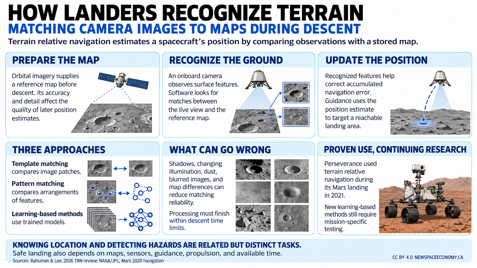
- Key Takeaways
- Terrain Relative Navigation Gives a Lander a Map-Based Position
- Image Matching Must Work Despite Changing Views
- Landmark Geometry Offers Another Route to Localization
- Deep Learning Can Improve Perception Without Settling Flight Readiness
- Maps and Sensors Set Limits That Algorithms Cannot Remove
- Real-Time Computing Turns a Research Method Into Flight Hardware
- Precision Landing Changes Mission Planning and Supplier Demand
- Summary
- Appendix: Useful Books Available on Amazon
- Appendix: Top Questions Answered in This Article
- Appendix: Glossary of Key Terms
Key Takeaways
- Terrain relative navigation compares observations with maps to estimate spacecraft location.
- Reliable landing depends on map quality, computing, sensors, and guidance working together.
- Learning-based methods show promise, but flight assurance remains a separate requirement.
Terrain Relative Navigation Gives a Lander a Map-Based Position
Perseverance landed in Jezero Crater on February 18, 2021, using a system that compared images taken during descent with an onboard map. The capability helped the spacecraft determine its position relative to mapped hazards before selecting a reachable landing location.
That process is terrain relative navigation (TRN). It addresses a limitation of relying on estimated motion alone: small uncertainties can accumulate as a vehicle approaches the surface. Observing recognizable terrain provides another way to determine where the spacecraft is.
A 2026 review of vision-based TRN, by Mohomad Aqeel Abdhul Rahuman and Kyuman Lee, organizes the research into template matching, pattern matching, and approaches incorporating deep learning. The review compares their strengths and limitations rather than identifying a universal winner.
The distinction between navigation and landing control is important. Navigation estimates position and motion. Guidance determines where the vehicle should go, and control directs its hardware to follow that plan. Better location information improves the process, but it does not independently guarantee a safe touchdown.
NASA’s description of Perseverance’s landing system separates the Lander Vision System from the decisions that use its output. The vision system was designed to determine map-relative position quickly, and the broader landing system used that information to select a safe, reachable target.
Reachability imposes physical limits. A spacecraft cannot select any attractive location visible in an image. Its remaining fuel and motion constrain where it can go before contact with the surface.
TRN also depends on information prepared before arrival. Orbital observations supply maps that describe the landing region, and mission teams identify hazards or areas unsuitable for touchdown. The descending spacecraft then relates what it sees to that prior information.
The technology changes which destinations can be considered. A location containing scientifically interesting terrain may also contain slopes or obstacles. More precise navigation can reduce some of the risk associated with reaching it, although the remaining hazards still require careful assessment.
New Space Economy’s TRN explainer provides broader context for that shift. The 2026 review adds a closer examination of the image-processing methods and hardware constraints that determine whether a promising algorithm can function during an actual descent.
Image Matching Must Work Despite Changing Views
A reference map and a descent image rarely look identical. They may have been captured from different heights and viewing angles. Lighting can also differ, changing the appearance of shadows and surface features.
Template matching compares image regions directly or through processed representations. The system searches for the part of a stored map that best corresponds to the current observation. When it finds a credible match, the location of that map region supports a position estimate.
This approach can work without identifying each feature as a named object. It relies on spatial patterns in the imagery. That can be useful where the visible surface contains texture but few clearly separated landmarks.
The search can become computationally expensive if the initial uncertainty is large. The system may need to compare an image against many possible map locations. A broad search also creates more chances for misleading similarities.
Hierarchical methods reduce that burden. A coarse search can narrow the possible region before a finer comparison estimates position more precisely. The review discusses this progression as a way to balance speed and accuracy.
Image preprocessing can improve comparability. It can reduce sensitivity to some differences in brightness or emphasize features useful for matching. Such processing does not eliminate every problem, because severe shadow changes or missing map detail may still prevent a reliable match.
A descent also changes the scale of the observation continuously. Features occupy more pixels as the spacecraft approaches the ground, and some leave the camera’s field of view. An algorithm must account for these changes within its operating window.
The review’s terrain-dependent comparisons should be read as guidance about method selection, rather than guarantees. A broad label such as flat terrain does not describe every image-processing condition. Lighting and map resolution can be just as consequential.
For an actual mission, the relevant question is whether the method remains dependable across the expected combinations of conditions. Average performance under favorable images is less informative than performance at the edges of the required operating range. Testing must include cases where the imagery is ambiguous or the initial estimate is less accurate than expected.
Landmark Geometry Offers Another Route to Localization
Pattern-matching approaches identify features and compare their spatial relationships with a stored representation. On cratered terrain, the system may use the arrangement of craters rather than relying only on the brightness pattern of a complete image.
Geometric relationships can be less sensitive to some lighting changes. A shadow may change the appearance of a crater, but its location relative to neighboring features can remain useful. The benefit depends on detecting the features consistently in the incoming image.
Feature detection is itself a demanding task. A partly shadowed crater may appear different from its map representation, and overlapping structures can complicate identification. Incorrectly identifying a feature can produce a plausible but wrong match.
The system needs enough distinctive information to separate candidate locations. Repeated patterns can create ambiguity, particularly if only a small region is visible. A collection of individually recognizable features is more useful when their combined arrangement is difficult to confuse with another location.
The review describes methods that use geometric properties to improve this process. Their suitability depends on the target body and the quality of its reference data. A method developed for a crater-rich surface may need substantial adaptation for a region with fewer distinct landmarks.
Altitude also changes which features are available. Large structures can support localization earlier in descent but move outside the field of view near the surface. Smaller features become visible later, provided the reference map contains enough detail to identify them.
This creates a relationship between orbital mapping and landing capability. Better surface maps can support better localization, but they need accurate coordinates as well as visually detailed imagery. An attractive image is not automatically a suitable navigation product.
New Space Economy’s discussion of the Mars Reconnaissance Orbiter connects reconnaissance with subsequent surface missions. Mapping spacecraft contribute to the information used by landing systems, extending their value beyond the original scientific observations.
Pattern matching also illustrates why TRN cannot be assessed by software alone. Sensor calibration and map preparation affect whether geometric comparisons mean what the algorithm assumes. Errors introduced elsewhere in the chain can limit the accuracy of an otherwise capable matching method.
Deep Learning Can Improve Perception Without Settling Flight Readiness
Deep learning uses computational models trained on data to recognize useful patterns. In TRN research, it can support feature detection or produce representations that make images easier to compare under changing conditions.
The 2026 review describes growing interest in these methods. Some approaches train models to recognize craters, and others learn image features useful for matching. The potential advantage is improved handling of visual differences that complicate conventional methods.
A trained model can also introduce dependencies that are less visible than those of a manually specified algorithm. Its performance depends on the data used during development. If the mission environment differs substantially from those data, successful laboratory results may not transfer.
Synthetic imagery can expand training datasets, but its usefulness depends on how well it represents the relevant conditions. A simulation can contain realistic-looking terrain yet miss a sensor effect or illumination condition that matters during flight.
The difference between detection and localization is also important. Correctly identifying a crater in an image does not by itself establish the spacecraft’s position. The system still needs to match that observation to a map and produce an estimate with an appropriate account of uncertainty.
The review identifies a gap between promising perception results and dependable end-to-end navigation. Closing it requires evaluating the whole processing chain. A model’s accuracy on selected images is only part of that work.
Computational requirements can be restrictive. A model that performs well on a powerful laboratory computer may need more memory or electrical power than the spacecraft can provide. Reducing its size can change its performance, so implementation choices require further testing.
Flight assurance adds another set of questions. Engineers need to understand how the system behaves when an image falls outside expected conditions and whether it can recognize an unreliable result. A confident wrong answer may be more dangerous than a rejected match that allows another navigation source to retain control.
The review supports continued development, not a claim that learning-based TRN has replaced established methods across planetary missions. Its most defensible implication is that machine learning can improve selected functions, provided those improvements survive the constraints and verification required by the complete landing system.
Maps and Sensors Set Limits That Algorithms Cannot Remove
A landing system cannot extract map information that was never recorded. If a reference product lacks suitable detail or contains location errors, software improvements alone cannot guarantee an accurate result.
The review emphasizes onboard map quality because TRN is relative to a stored representation. A spacecraft can match an image correctly to a map that is itself offset. The matching process may appear successful even though the resulting coordinates carry the map’s error.
Resolution creates another limit. Features visible in a descent image may be smaller than the reference map can represent. Conversely, a coarse observation during high-altitude descent may not contain enough information to distinguish nearby map locations.
Sensor performance affects the available evidence. Camera exposure and image motion influence whether features remain recognizable. Calibration errors can also distort the relationship between image coordinates and the direction of an observed feature.
Low illumination presents a separate difficulty for passive cameras. A camera depends on light from the scene, and deeply shadowed terrain can provide little useful detail. Increasing sensitivity does not remove every problem, because image noise and motion still constrain the observation.
Active sensors offer a complementary approach. Light detection and ranging, commonly called lidar, sends light toward the surface and measures the return. It can provide information without depending on sunlight in the same way as a conventional camera.
Combining sensors can improve the overall estimate, but sensor fusion requires careful handling of their different uncertainties. Conflicting observations need to be detected and resolved. Adding another instrument also adds mass and integration work.
NASA’s continuing precision-landing development illustrates the importance of testing complete sensor and processing combinations. Mission readiness depends on how the components work together under relevant conditions.
At the lunar poles, these issues become closely connected. Low Sun angles can produce long shadows, and surface relief affects visibility. A mission needs a navigation design suited to its actual site and timing, rather than assuming that a method successful elsewhere will perform identically.
Real-Time Computing Turns a Research Method Into Flight Hardware
A descending vehicle has limited time to process observations. A navigation estimate delivered after the relevant maneuver opportunity has passed may be accurate yet operationally useless.
Real-time performance concerns dependable timing, not simply a high average processing speed. The system must complete its tasks within required deadlines under the conditions expected during descent. Occasional long delays can matter even when most images are processed quickly.
Spaceflight hardware also faces constraints that differ from laboratory computers. Power and thermal limits restrict processing options. Radiation tolerance and fault handling influence component selection, and the available hardware may not support a research algorithm without modification.
The review describes hybrid architectures that divide work between processors and specialized programmable hardware. Image-intensive tasks can be handled separately from general control functions. The benefit comes from matching the hardware to the processing workload.
NASA’s Perseverance hardware description identifies a dedicated Vision Compute Element with a field-programmable gate array used for image analysis. That is evidence of an integrated engineering solution, rather than a camera operating independently of the rest of the spacecraft.
A field-programmable gate array can implement specialized processing operations in parallel. Its usefulness comes with development effort, because the hardware logic must be designed and verified. It is not automatically interchangeable with ordinary software running on a processor.
Reliability also requires handling incomplete or unexpected data. A camera can return an unusable image, and a matching process can fail to find a convincing location. The navigation architecture must define what happens in those cases.
The system may continue using other measurements until a credible match becomes available. Such behavior depends on the broader design, including the uncertainty already present in the vehicle’s estimate. Failure handling cannot be specified sensibly without considering the mission’s remaining options.
New Space Economy’s spacecraft-navigation history places visual navigation within a longer progression of complementary methods. TRN adds valuable information, but successful flight architectures use that information within a coordinated system of sensing and control.
Precision Landing Changes Mission Planning and Supplier Demand
Improved landing accuracy can affect the design of a mission well before launch. It can make some sites more accessible or reduce the distance between touchdown and the work the mission intends to perform.
Those benefits remain conditional. A scientifically useful site may still contain hazards the spacecraft cannot tolerate. Better navigation reduces uncertainty about location, but it does not change the strength of a landing leg or the stability of the ground beneath it.
Future surface infrastructure introduces additional constraints. Landing near equipment may reduce transportation needs, but the descent can expose that equipment to material displaced by rocket exhaust. Precise placement must be considered alongside the effects of the landing itself.
The economics involve more than selling a navigation algorithm. Mission teams need suitable maps and calibrated sensors. They also need simulation and testing services capable of evaluating the integrated design.
A supplier’s performance claim must match the mission’s requirements. An accuracy figure has limited meaning without the conditions under which it was obtained. It should identify the map reference and the relevant operating range, together with the confidence associated with the estimate.
Demonstrations can reduce uncertainty, but their relevance depends on what they reproduce. A terrestrial flight test can examine real sensors and processing hardware, yet it does not reproduce every feature of a lunar or Martian descent. The remaining differences need to be addressed through other evidence.
The review’s comparison of methods supports procurement based on mission fit. It does not support choosing a system solely because it uses a newer algorithm. An established method may be appropriate if it meets the requirements with a clearer verification path.
The wider history of Mars landings shows how navigation improvements enter a larger landing architecture. Each improvement becomes valuable through integration with the vehicle’s other systems.
TRN’s future development will depend on that same relationship. Better perception and stronger computing can expand capability, but flight evidence must establish when the system can be trusted. The commercial product is dependable mission performance, with the algorithm serving as one contributor.
Summary
Terrain relative navigation helps a spacecraft determine where it is by comparing observations with a prepared map. Its effectiveness depends on a chain that includes reference data and sensors, followed by processing and guidance.
The 2026 review shows why no single image-matching approach is best for every destination. Different terrain and illumination conditions favor different methods, and learning-based techniques introduce both useful capabilities and additional verification work.
The next improvement may come from better integration rather than an isolated increase in algorithm accuracy. A system that identifies uncertain results and delivers dependable estimates on flight hardware can be more useful than one that performs exceptionally under a narrower set of laboratory conditions.
Appendix: Useful Books Available on Amazon
- Computer Vision: Algorithms and Applications
- Spacecraft Dynamics and Control: An Introduction
- Elements of Spacecraft Design
- Spacecraft Systems Engineering
- Space Mission Engineering: The New SMAD
Appendix: Top Questions Answered in This Article
What is terrain relative navigation?
Terrain relative navigation estimates a spacecraft’s location by comparing observations of the surface with a stored map. It supplies information to the wider navigation system. Guidance then uses that estimate, together with other constraints, to select and pursue an appropriate landing location.
How did Perseverance use it?
Perseverance’s Lander Vision System compared descent images with an onboard map during its approach to Jezero Crater. The broader landing system used the resulting position estimate to select a reachable location that avoided mapped hazards. The mission landed successfully on February 18, 2021.
Does TRN control the engines directly?
TRN primarily provides navigation information. Guidance determines the desired motion, and control systems command the vehicle’s hardware to achieve it. These functions work together, but distinguishing them prevents an image-processing capability from being mistaken for the entire landing system.
What is template matching?
Template matching compares an observed image region with candidate regions in a reference map. The system searches for a credible correspondence and uses its map location to support localization. Differences in lighting and image scale can make the comparison more difficult.
What is pattern matching?
Pattern matching identifies features and compares their geometric relationships with a stored representation. Crater arrangements can support this approach on suitable terrain. Success depends on reliable feature detection and enough distinctive information to avoid confusing one location with another.
How can deep learning help?
Deep learning can improve feature detection or create image representations useful for matching. Its performance depends on training data and operating conditions. Laboratory accuracy does not independently establish that a model will remain dependable on flight hardware during an actual planetary descent.
Why do reference maps matter?
TRN estimates position relative to a map, so map errors can affect the result even when image matching succeeds. Resolution and coordinate accuracy both matter. Better algorithms cannot fully compensate for missing features or an incorrectly located reference product.
Can cameras operate in permanent shadow?
Passive cameras depend on available light, which can be insufficient in deeply shadowed terrain. Active sensors such as lidar can provide complementary measurements. Their integration adds engineering requirements, and the complete system must be evaluated for the conditions at the intended landing site.
Why is processing speed important?
A descent leaves limited time for decisions. A position estimate must arrive before the maneuver that needs it, making dependable processing deadlines important. High average speed alone is insufficient if the system sometimes produces results too late for safe use.
Does better navigation guarantee a safe landing?
Better navigation reduces uncertainty about location, but landing also depends on the vehicle and the surface. Remaining fuel limits reachable locations, and touchdown hazards still matter. TRN must operate within a complete landing architecture that includes appropriate guidance and fault handling.
Appendix: Glossary of Key Terms
Localization
The process of estimating a vehicle’s position relative to a reference. In terrain relative navigation, the reference is a map of the surface, and the estimate depends on matching current observations with information stored before descent.
Sensor Fusion
The combination of information from multiple sensors to produce an estimate. Each sensor has different strengths and uncertainties, so the process must account for disagreement and avoid treating every measurement as equally reliable.
Lidar
An active sensing method that emits light and measures the returning reflection. It can provide distance or surface-shape information, making it useful where a passive camera lacks sufficient illumination or needs complementary geometric measurements.
Field-Programmable Gate Array
An electronic device whose internal logic can be configured for specialized processing. Space systems can use it to perform image operations in parallel, although its design and verification require work different from ordinary software development.